How Satellites Aid in Logistics and Supply Chain Management
In today's fast-paced world, where every second counts, satellites have become the unsung heroes of logistics and supply chain management. Imagine a world where goods can be tracked in real-time, where delays are minimized, and where decisions are made with data-driven precision. This is not just a dream; it is the reality brought to life by satellite technology. From monitoring shipments to optimizing routes, satellites play a crucial role in enhancing the efficiency and effectiveness of logistics operations. Let’s dive deeper into how these technological marvels are transforming the landscape of supply chain management.
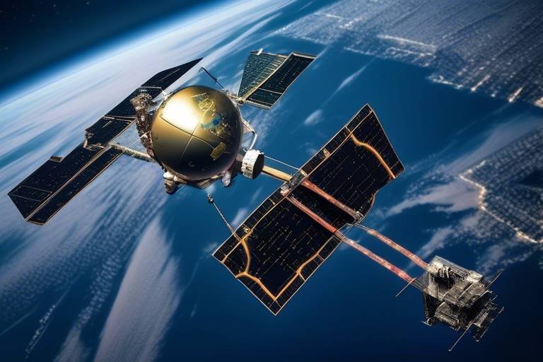
Satellite technology has revolutionized various industries, including logistics. There are primarily two types of satellites used in this field: communication satellites and Earth observation satellites. Communication satellites facilitate the transmission of data between locations, ensuring that logistics companies can communicate effectively with their fleet and partners. On the other hand, Earth observation satellites gather data about the Earth's surface, providing critical information about weather patterns, traffic conditions, and geographical changes that can impact logistics operations. Together, these satellites create a robust network that enhances operational capabilities.
One of the most significant advantages of satellite technology is its ability to provide real-time tracking of shipments. This capability allows companies to monitor their goods continuously, ensuring that they are aware of their location at all times. Imagine the peace of mind that comes with knowing exactly where your shipment is, whether it’s on the road, at a port, or in a warehouse. This visibility not only enhances accountability but also allows for proactive problem-solving. For instance, if a shipment is delayed, logistics managers can quickly identify the issue and make informed decisions to mitigate the impact on delivery schedules.
The Global Positioning System (GPS), powered by satellites, offers precise location tracking that is invaluable in logistics. With GPS, logistics companies can optimize routes, reducing travel time and fuel consumption. This is akin to having a personal navigator who knows the best paths to take, avoiding traffic jams and road closures. The impact of GPS on delivery efficiency is profound, as it allows for more accurate arrival times and better planning for resources. Additionally, the data collected from GPS tracking can be analyzed to identify trends and patterns, further enhancing operational efficiency.
With accurate tracking, logistics companies can streamline their delivery schedules. Think of it as fine-tuning a musical instrument; when every note is in harmony, the result is a flawless performance. Timely deliveries not only enhance customer satisfaction but also improve operational efficiency. Customers today expect their orders to arrive on time, and meeting these expectations can significantly boost a company's reputation. Moreover, consistent delivery performance can lead to increased business opportunities and customer loyalty.
Efficient tracking can lead to significant cost savings for logistics companies. By minimizing fuel consumption through optimized routing and reducing delays, companies can operate more cost-effectively. For instance, consider a logistics firm that implements satellite tracking and discovers that certain routes consistently lead to delays. By adjusting their routes based on satellite data, they can save both time and money. These savings can then be reinvested into the business, fostering growth and innovation.
Satellites provide valuable data that can be harnessed for analytics, enabling better decision-making. The data collected from satellite tracking can be analyzed to forecast demand, manage inventory, and optimize supply chain operations. This is much like having a crystal ball that reveals future trends, allowing companies to make informed decisions that align with market demands. For example, if satellite data indicates a surge in demand for a particular product, companies can adjust their inventory levels accordingly, ensuring they are well-prepared to meet customer needs.
In times of crisis, satellites play a vital role in disaster management. They provide essential data that helps companies plan for contingencies, ensuring that they can respond effectively to unexpected events. Whether it’s a natural disaster disrupting transportation routes or a sudden spike in demand due to unforeseen circumstances, satellite data equips organizations with the insights they need to navigate challenges. This ability to adapt and respond is crucial for maintaining supply chain resilience.
Building resilience in supply chains is essential for business continuity. Satellite technology helps organizations adapt to disruptions by providing real-time information and predictive analytics. For instance, if a hurricane is approaching, companies can use satellite data to reroute shipments or adjust delivery schedules proactively. This flexibility not only protects assets but also ensures that customer commitments are met, even in challenging circumstances.
The future of logistics is increasingly intertwined with satellite technology. Emerging trends, such as the integration of artificial intelligence and machine learning with satellite data, are set to revolutionize the industry further. Imagine a logistics system that not only tracks shipments but also predicts potential delays and suggests optimal routes in real time. As technology continues to advance, the possibilities are endless, paving the way for more efficient and resilient supply chains.
- How do satellites improve supply chain visibility? Satellites provide real-time tracking and monitoring, allowing companies to see the exact location of their shipments at any given moment.
- What is the role of GPS in logistics? GPS technology, powered by satellites, offers precise location tracking, enabling route optimization and improving delivery efficiency.
- Can satellite data help in disaster management? Yes, satellite data is crucial for disaster management, providing essential information that helps companies plan for contingencies and adapt to disruptions.
- What are the future trends in satellite logistics? Future trends include the integration of AI and machine learning with satellite data, enhancing predictive analytics and operational efficiency.
Overview of Satellite Technology
Satellite technology has revolutionized various industries, and logistics is no exception. At its core, satellite technology involves the use of orbiting devices that can communicate with ground stations and other satellites. These devices are equipped with advanced sensors and communication tools that allow them to gather and relay vital information. There are several types of satellites that serve different purposes in logistics, including:
- Communication Satellites: These are essential for transmitting data between different locations, ensuring that logistics companies can stay connected with their fleets and operations.
- Earth Observation Satellites: They provide crucial information about weather patterns, traffic conditions, and geographical changes, which can significantly impact supply chain decisions.
- Navigational Satellites: Primarily used for GPS technology, these satellites help in precise location tracking and route optimization.
One of the most significant advancements in satellite technology is its ability to provide real-time data. This means that logistics companies can monitor their shipments continuously, allowing for better visibility throughout the supply chain. Imagine being able to track a package from the moment it leaves the warehouse until it arrives at the customer's doorstep—this level of transparency not only enhances operational efficiency but also builds trust with customers.
Furthermore, the integration of satellite technology with other innovations like the Internet of Things (IoT) and big data analytics is paving the way for smarter logistics solutions. For instance, sensors embedded in shipping containers can relay information about temperature, humidity, and even tampering, all thanks to satellite communication. This data can be crucial for industries where product integrity is paramount, such as pharmaceuticals and food services.
In summary, satellite technology is a game changer in logistics and supply chain management. It provides the tools necessary for real-time tracking, enhances communication, and supports data-driven decision-making. As we dive deeper into the specifics of how these technologies improve logistics operations, it becomes clear that the future of supply chain management will be heavily reliant on satellite technology.
Real-Time Tracking and Monitoring
Imagine you're waiting for a package that contains a long-awaited gift. The anticipation builds as you wonder: "Where is my package right now?" This is where real-time tracking via satellites comes into play, transforming the logistics landscape into something remarkably efficient and transparent. With the power of satellite technology, companies can monitor their shipments continuously, providing them with a bird's-eye view of the entire supply chain process. This capability not only enhances visibility but also fosters accountability among all parties involved.
Real-time tracking is like having a GPS tracker for your shipments, allowing logistics companies to pinpoint the exact location of their goods at any moment. This is especially crucial in a world where time is money, and delays can lead to significant losses. By utilizing satellite systems, businesses can quickly identify and respond to potential delays or disruptions, ensuring that their operations run smoothly. The result? A more agile supply chain that can pivot and adapt to changing circumstances.
Furthermore, the integration of satellite tracking systems has led to the development of sophisticated monitoring dashboards. These tools provide logistics managers with a comprehensive overview of their shipments, showing not just where items are, but also their estimated arrival times, environmental conditions during transit, and any potential risks they may face. This level of insight enables companies to make informed decisions quickly, optimizing routes and ensuring that their deliveries arrive on time.
To illustrate the impact of real-time tracking, consider the following table that compares traditional tracking methods with satellite-based tracking:
| Feature | Traditional Tracking | Satellite Tracking |
|---|---|---|
| Location Updates | Periodic updates | Continuous updates |
| Response Time to Issues | Delayed response | Immediate response |
| Visibility | Limited visibility | Full visibility |
| Data Accuracy | Moderate accuracy | High accuracy |
This table clearly shows that satellite tracking offers significant advantages over traditional methods, especially when it comes to real-time updates and data accuracy. As businesses increasingly recognize the importance of visibility in their operations, the adoption of satellite technology for tracking and monitoring is becoming more prevalent.
In conclusion, real-time tracking and monitoring through satellite technology not only enhances operational efficiency but also builds trust with customers. When clients can see where their shipments are at any given moment, it alleviates anxiety and fosters a sense of reliability. As logistics companies continue to embrace this technology, we can expect to see even greater improvements in the overall supply chain management process.
- How does satellite tracking work? Satellite tracking uses satellite signals to determine the exact location of a shipment in real-time, providing continuous updates to logistics managers.
- What are the benefits of real-time tracking? The benefits include enhanced visibility, immediate response to issues, improved customer satisfaction, and optimized operational efficiency.
- Can satellite tracking reduce delivery delays? Yes, by providing accurate location data, companies can quickly address potential delays and optimize routes, leading to timely deliveries.
Benefits of GPS in Logistics
When we think about the logistics industry, it's hard to ignore the profound impact that Global Positioning System (GPS) technology has made. Imagine navigating through a maze without a map; that's how logistics used to operate before GPS came into play. Now, with the ability to pinpoint locations with incredible accuracy, logistics companies can ensure that their operations run like a well-oiled machine. The benefits are numerous and far-reaching, making GPS an indispensable tool in modern supply chain management.
One of the most significant advantages of GPS technology is its ability to provide real-time location tracking. This means that companies can monitor their shipments at any given moment. No more guessing games or anxious phone calls to drivers about their whereabouts. When a shipment is on the move, GPS allows for continuous tracking, giving companies a clear view of the entire supply chain process. This level of visibility not only enhances operational efficiency but also builds trust with customers, who appreciate knowing exactly when their orders will arrive.
Furthermore, GPS technology plays a pivotal role in route optimization. By analyzing traffic patterns, weather conditions, and road closures, logistics companies can determine the most efficient routes for their deliveries. This capability not only saves time but also reduces fuel consumption, which is a significant cost factor in logistics. With less time spent on the road and fewer miles driven, companies can pass those savings on to their customers, creating a win-win situation. In fact, studies have shown that businesses utilizing GPS for route optimization can see a reduction in delivery times by up to 25%.
Another noteworthy benefit is the enhancement of customer satisfaction. In today's fast-paced world, customers expect timely deliveries. With GPS, logistics companies can provide accurate estimated delivery times, allowing customers to plan accordingly. Imagine ordering a package and receiving a notification that it will arrive within a specific window. This not only improves the customer experience but also fosters loyalty and repeat business. In a competitive marketplace, such differentiation can be a game-changer.
Moreover, GPS technology aids in inventory management. By tracking shipments in real-time, companies can better manage their stock levels. They can anticipate when products will arrive and adjust their inventory accordingly. This proactive approach minimizes the risk of overstocking or stockouts, ensuring that businesses can meet customer demand without tying up unnecessary capital in excess inventory.
In summary, the benefits of GPS in logistics are undeniable. From real-time tracking to route optimization and enhanced customer satisfaction, GPS technology has transformed the way logistics companies operate. As we move forward, the integration of GPS with other technologies, such as artificial intelligence and machine learning, promises even greater advancements in efficiency and effectiveness in the logistics sector.
- What is GPS and how does it work in logistics? GPS, or Global Positioning System, is a satellite-based navigation system that allows logistics companies to track the precise location of their shipments in real-time.
- How does GPS improve delivery times? By providing real-time data on traffic and road conditions, GPS enables logistics companies to choose the quickest routes, thereby reducing delivery times.
- Can GPS technology help reduce operational costs? Yes, by optimizing routes and minimizing fuel consumption, GPS can lead to significant cost savings for logistics companies.
- What role does GPS play in customer satisfaction? GPS technology allows companies to provide accurate delivery estimates, which enhances the customer experience and builds trust.
Enhanced Delivery Timelines
In today's fast-paced world, where instant gratification is the norm, are no longer just a luxury; they are a necessity. Thanks to satellite technology, logistics companies can now provide customers with accurate delivery estimates, improving overall satisfaction. Imagine ordering a package and knowing exactly when it will arrive—this is the magic of real-time tracking! By utilizing satellites, companies can gain unprecedented visibility into their supply chains, allowing them to make informed decisions that lead to timely deliveries.
One of the most significant advantages of satellite technology is its ability to optimize routes. With precise location tracking, logistics providers can analyze traffic patterns, weather conditions, and other variables that might affect delivery times. This means that instead of taking the usual route, a delivery truck can be rerouted to avoid traffic jams or bad weather, ensuring that packages reach their destinations on time. The result? Happier customers and a more efficient operation.
Moreover, the implementation of satellite technology in logistics can drastically reduce the chances of delays caused by unforeseen circumstances. For instance, if a natural disaster strikes, satellite imagery can provide real-time information about road closures or hazardous conditions. This allows companies to quickly adapt their delivery schedules and communicate changes to customers, maintaining transparency and trust. The ability to react swiftly to such situations is a game-changer in the logistics industry.
To illustrate the impact of enhanced delivery timelines, consider the following table that compares traditional delivery methods with satellite-assisted logistics:
| Aspect | Traditional Delivery | Satellite-Assisted Delivery |
|---|---|---|
| Route Optimization | Limited to pre-planned routes | Dynamic rerouting based on real-time data |
| Delivery Estimates | Often inaccurate | Real-time tracking provides accurate ETAs |
| Response to Disruptions | Slow and reactive | Proactive adjustments based on satellite data |
| Customer Communication | Limited updates | Frequent updates and transparency |
In addition to improving delivery timelines, satellite technology also enhances the overall customer experience. With real-time updates, customers can track their packages from the moment they leave the warehouse until they arrive at their doorstep. This level of transparency fosters trust and builds loyalty, as customers feel more connected to the process. After all, who doesn't appreciate knowing exactly where their package is at any given moment?
In conclusion, the integration of satellite technology into logistics not only enhances delivery timelines but also transforms the entire customer experience. By leveraging real-time data, companies can optimize routes, respond to disruptions, and keep customers informed every step of the way. As we continue to embrace technological advancements, the future of logistics looks brighter than ever!
Reducing Operational Costs
In today's fast-paced logistics environment, is not just a goal; it's a necessity. Companies are constantly searching for ways to streamline their processes and maximize efficiency. One of the most effective strategies to achieve this is through the use of satellite technology. By leveraging the capabilities of satellites, logistics companies can significantly cut down on expenses while improving service delivery.
Firstly, let's consider fuel consumption. Fuel is one of the largest operational costs for logistics companies. With satellite technology, companies can utilize real-time data to optimize routes. Instead of relying on traditional mapping methods, which may not account for current traffic conditions or road closures, satellite systems provide up-to-the-minute information. This means that drivers can avoid congested areas and select the most efficient routes, ultimately leading to reduced fuel consumption.
Moreover, satellite tracking systems allow for better fleet management. By monitoring vehicle locations and performance, companies can identify underperforming assets and make informed decisions about maintenance schedules. This proactive approach helps to prevent costly breakdowns and extends the lifespan of vehicles. A well-maintained fleet not only saves money on repairs but also enhances overall operational efficiency.
Additionally, satellite technology enables businesses to improve their inventory management. With precise tracking of shipments, companies can better predict arrival times and manage stock levels more effectively. This level of visibility helps to minimize overstocking and stockouts, both of which can be financially detrimental. By aligning inventory with actual demand, companies can reduce waste and optimize storage costs.
To illustrate the impact of satellite technology on operational costs, consider the following table:
| Cost Area | Traditional Method | With Satellite Technology | Cost Savings |
|---|---|---|---|
| Fuel Consumption | High due to inefficient routing | Optimized routes reduce fuel use | Up to 20% savings |
| Vehicle Maintenance | Reactive maintenance schedules | Proactive management based on data | Up to 15% savings |
| Inventory Costs | Overstocking and stockouts | Better demand forecasting | Up to 30% savings |
In summary, the integration of satellite technology in logistics not only enhances operational efficiency but also plays a pivotal role in reducing costs. By optimizing routes, improving fleet management, and enhancing inventory control, companies can achieve significant financial benefits. The ability to make data-driven decisions allows businesses to stay competitive in an ever-evolving market.
- How does satellite technology improve route optimization?
Satellite technology provides real-time traffic updates and road conditions, allowing drivers to choose the most efficient routes and avoid delays. - Can satellite tracking reduce fuel costs?
Yes, by optimizing routes and reducing unnecessary travel, satellite tracking can lead to significant fuel savings. - What impact does satellite technology have on inventory management?
Satellite technology offers precise tracking of shipments, enabling better forecasting and reducing both overstocking and stockouts. - Is satellite technology expensive to implement?
While there may be initial setup costs, the long-term savings from improved efficiency and reduced operational costs often outweigh these expenses.
Data Analytics and Decision Making
In today's fast-paced world, data analytics has become the backbone of informed decision-making, especially in logistics and supply chain management. Imagine trying to navigate a vast ocean without a map; that’s what businesses face without the insights provided by satellite data. By harnessing the power of satellite technology, companies can collect and analyze vast amounts of data, leading to improved operational efficiency and strategic planning.
Satellites gather real-time information on various parameters, such as weather conditions, traffic patterns, and shipment locations. This data can be processed and analyzed to uncover trends and patterns that are crucial for making timely decisions. For instance, if a logistics company notices a significant weather disruption in a particular region, they can quickly reroute shipments, minimizing delays and ensuring that goods reach their destinations on time.
Moreover, the integration of satellite data with advanced analytics tools allows businesses to forecast demand more accurately. By analyzing historical data alongside real-time satellite information, companies can predict inventory needs with greater precision, reducing the risk of overstocking or stockouts. This not only leads to better resource allocation but also enhances customer satisfaction as products are available when needed.
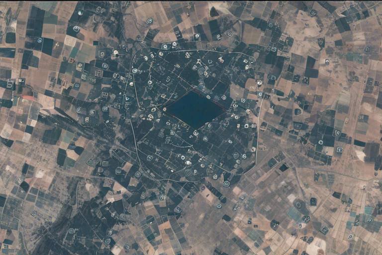
Additionally, the ability to visualize data through satellite imagery provides a comprehensive view of supply chain operations. Companies can assess their entire logistics network, identifying bottlenecks and inefficiencies. For example, a logistics manager can utilize satellite imagery to analyze traffic congestion in urban areas, enabling them to adjust delivery routes proactively. This level of insight empowers organizations to make data-driven decisions that enhance overall performance.
To illustrate the impact of data analytics in decision-making, consider the following table that summarizes key benefits:
| Benefit | Description |
|---|---|
| Improved Forecasting | Utilizing historical and real-time data to predict future demand accurately. |
| Enhanced Visibility | Gaining a comprehensive view of the supply chain, leading to better monitoring. |
| Proactive Decision-Making | Enabling quick responses to disruptions based on real-time data analysis. |
| Cost Efficiency | Reducing operational costs through optimized resource allocation and route planning. |
As we move forward, the synergy between satellite technology and data analytics will only grow stronger. Companies that embrace these tools will not only stay competitive but also set themselves up for long-term success. In a world where information is power, leveraging satellite data to inform decisions is akin to holding a treasure map in a world full of uncertainty. Are you ready to navigate your way to success?
- How do satellites improve supply chain visibility? Satellites provide real-time data on shipment locations and environmental conditions, enhancing overall visibility in the supply chain.
- What role does data analytics play in logistics? Data analytics helps companies forecast demand, optimize routes, and make informed decisions based on real-time data.
- Can satellite data reduce operational costs? Yes, by optimizing routes and improving efficiency, satellite data can significantly lower operational costs.
- What future trends can we expect in satellite logistics? Emerging trends include increased use of AI for data analysis and the integration of IoT devices for better tracking and monitoring.
Disaster Management and Contingency Planning
In an unpredictable world, where natural disasters can strike at any moment, the importance of disaster management and contingency planning cannot be overstated. Satellite technology has emerged as a critical player in this arena, providing real-time data that helps organizations prepare for, respond to, and recover from crises. Imagine a company that relies on timely deliveries of essential goods—when a hurricane approaches, how can they ensure their supply chain remains intact? This is where the power of satellites comes into play.
Satellites offer a bird's-eye view of disaster situations, allowing businesses to track weather patterns, monitor affected areas, and assess damage after an event. With this information, companies can make informed decisions about rerouting shipments, reallocating resources, or even temporarily halting operations in high-risk areas. The ability to foresee potential disruptions allows organizations to create robust contingency plans that can save both time and money.
Furthermore, satellite data can significantly enhance communication during disasters. Traditional communication lines may fail during emergencies, but satellite systems remain operational, providing a reliable means of communication. This ensures that logistics teams can coordinate effectively, sharing critical updates and making real-time adjustments as situations evolve. For example, if a road becomes impassable due to flooding, logistics managers can quickly reroute deliveries to maintain service levels.
To illustrate the impact of satellite technology in disaster management, consider the following table that outlines key benefits:
| Benefit | Description |
|---|---|
| Real-Time Data | Access to immediate information about weather conditions and disaster impacts. |
| Improved Communication | Reliable communication channels during emergencies, ensuring coordination. |
| Resource Allocation | Enhanced decision-making regarding the deployment of resources and personnel. |
| Risk Assessment | Ability to assess risks and vulnerabilities in the supply chain. |
Ultimately, the integration of satellite technology into disaster management and contingency planning is not just a luxury; it’s a necessity. Companies that leverage this technology can build a resilient supply chain that withstands disruptions and ensures business continuity. In a world where the unexpected is always lurking around the corner, having the right tools and strategies in place can make all the difference.
- How do satellites help in disaster management? Satellites provide real-time data on weather patterns and disaster impacts, enabling organizations to make informed decisions during crises.
- Can satellite communication work during a disaster? Yes, satellite communication remains operational even when traditional communication lines fail, ensuring reliable coordination.
- What role does data analytics play in contingency planning? Data analytics helps organizations assess risks, forecast potential disruptions, and develop effective contingency plans.
- Are there specific satellites used for logistics? Yes, various satellites are designed for tracking and communication, specifically tailored to meet the needs of logistics and supply chain management.
Supply Chain Resilience
In today's fast-paced world, the ability to adapt and respond to unexpected disruptions is more important than ever. refers to the capacity of a supply chain to prepare for, respond to, and recover from adverse situations. With the integration of satellite technology, businesses can enhance their resilience significantly. Imagine a storm brewing on the horizon; without the right tools, a company might find itself scrambling to adapt. However, with satellite data, businesses can foresee disruptions and make informed decisions to mitigate risks.
Satellites provide real-time information about weather patterns, traffic conditions, and even geopolitical events that could affect logistics. This data is crucial for companies to develop contingency plans. For instance, if a natural disaster is detected in a specific area, organizations can reroute shipments to avoid delays, ensuring that they meet customer expectations even in challenging circumstances. The ability to pivot quickly is what separates resilient companies from those that struggle to survive.
Furthermore, the data collected from satellites can aid in risk assessment and management. Companies can analyze historical data to identify potential vulnerabilities in their supply chains. By understanding where weaknesses lie, businesses can proactively strengthen those areas. For example, if a certain route is frequently affected by weather-related disruptions, a company can invest in alternative routes or modes of transport. This is akin to building a fortified wall around a castle; it’s not just about defending against attacks but also about ensuring that the castle can withstand any siege.
To illustrate the impact of satellite technology on supply chain resilience, consider the following table that outlines the key benefits:
| Benefit | Description |
|---|---|
| Proactive Risk Management | Identifying potential disruptions before they occur allows companies to take preventive measures. |
| Improved Communication | Real-time updates ensure that all stakeholders are informed, facilitating better coordination. |
| Alternative Routing | Satellite data enables businesses to quickly find alternative routes to avoid delays. |
| Enhanced Decision Making | Data analytics from satellite sources aids in making informed decisions during crises. |
In conclusion, the integration of satellite technology into supply chain management is not just a trend; it's a necessity for building resilience. Companies that leverage this technology can not only weather the storms of disruption but can also emerge stronger and more agile. As we move forward, the importance of adaptability will only grow, making supply chain resilience a critical focus for businesses aiming for long-term success.
- What is supply chain resilience?
Supply chain resilience is the ability of a supply chain to prepare for, respond to, and recover from disruptions effectively. - How do satellites contribute to supply chain resilience?
Satellites provide real-time data on various factors that can impact supply chains, allowing companies to make informed decisions and adapt quickly. - Can satellite technology help reduce costs?
Yes, by optimizing routes and improving communication, satellite technology can lead to significant cost savings in logistics. - Is satellite technology only beneficial during disasters?
No, while it is crucial during disasters, satellite technology also enhances everyday operations by improving visibility and efficiency.
Future Trends in Satellite Logistics
The logistics industry is on the brink of a transformational leap, thanks to the ever-evolving capabilities of satellite technology. As we peer into the future, several key trends are emerging that promise to reshape how logistics and supply chain management operate. One of the most exciting trends is the increasing integration of Internet of Things (IoT) devices with satellite systems. Imagine a world where every shipment is equipped with sensors that communicate real-time data back to satellites, allowing for unprecedented levels of tracking and monitoring. This synergy not only enhances visibility but also opens the door to predictive analytics, enabling companies to anticipate issues before they arise.
Another trend gaining traction is the rise of miniaturized satellites, commonly referred to as CubeSats. These smaller, more affordable satellites can be deployed in larger numbers, creating a dense network of coverage. This innovation means that even remote areas, previously considered logistical black holes, can now be monitored and managed efficiently. Companies can track shipments across challenging terrains, ensuring that goods reach their destinations without unnecessary delays.
Furthermore, advancements in artificial intelligence (AI) are set to revolutionize how satellite data is analyzed and utilized. By leveraging AI algorithms, logistics companies can sift through vast amounts of data collected from satellites, extracting actionable insights that lead to smarter decision-making. For instance, AI can help identify optimal routes by analyzing traffic patterns, weather conditions, and shipment priorities, thereby enhancing delivery efficiency and reducing operational costs.
Moreover, the concept of autonomous logistics is becoming more feasible with the help of satellite technology. Picture drones and autonomous vehicles that navigate using satellite-guided GPS systems, delivering packages to customers with minimal human intervention. This not only speeds up the delivery process but also reduces the chances of human error, leading to a more reliable service. Companies are already piloting these technologies, and as they become more mainstream, we can expect a significant shift in how goods are transported.
To encapsulate these trends, here's a brief overview of how they impact the logistics landscape:
| Trend | Description | Impact on Logistics |
|---|---|---|
| IoT Integration | Combining IoT devices with satellite systems for real-time data. | Enhanced tracking and predictive analytics. |
| Miniaturized Satellites | Deployment of CubeSats for broader coverage. | Improved monitoring in remote areas. |
| Artificial Intelligence | Using AI for data analysis from satellites. | Smarter decision-making and optimized routes. |
| Autonomous Logistics | Utilizing drones and autonomous vehicles. | Faster, more reliable deliveries. |
In conclusion, the future of satellite logistics is bright and full of potential. As technology continues to advance, the logistics industry will undoubtedly become more efficient, transparent, and resilient. Companies that embrace these trends will not only gain a competitive edge but will also be better equipped to meet the challenges of a rapidly changing market.
- How do satellites improve supply chain efficiency?
Satellites enhance supply chain efficiency by providing real-time tracking, enabling better visibility, and facilitating data-driven decision-making. - What role does AI play in satellite logistics?
AI analyzes satellite data to optimize routes, predict delays, and improve overall logistics operations. - Are miniaturized satellites cost-effective?
Yes, miniaturized satellites, like CubeSats, are more affordable and can be deployed in larger numbers, improving coverage and monitoring capabilities. - What is autonomous logistics?
Autonomous logistics refers to the use of drones and self-driving vehicles for delivery, guided by satellite technology.
Frequently Asked Questions
- What role do satellites play in logistics?
Satellites are essential in logistics as they provide real-time tracking and monitoring of shipments. This capability enhances visibility throughout the supply chain, allowing companies to manage their operations more effectively and make informed decisions based on accurate data.
- How does GPS technology improve delivery efficiency?
GPS technology, powered by satellites, allows for precise location tracking of vehicles and shipments. This helps logistics companies optimize their routes, reduce delivery times, and ultimately improve customer satisfaction by ensuring timely deliveries.
- Can satellite technology help reduce operational costs?
Absolutely! By providing real-time data on vehicle locations and traffic conditions, satellite technology enables logistics companies to minimize fuel consumption and reduce delays, leading to significant cost savings over time.
- What kind of data do satellites provide for decision-making?
Satellites collect a wealth of data that can be analyzed for various purposes, including forecasting demand, managing inventory levels, and optimizing supply chain operations. This data-driven approach allows companies to make better strategic decisions and enhance overall efficiency.
- How do satellites assist in disaster management?
In times of crisis, satellite data is invaluable for disaster management. It helps companies assess the situation, plan for contingencies, and adapt their supply chains to ensure business continuity, thereby building resilience against disruptions.
- What are the future trends in satellite logistics?
The future of satellite logistics looks promising, with emerging technologies such as advanced satellite imagery and AI-driven analytics. These innovations are expected to further enhance tracking capabilities, improve data accuracy, and streamline logistics processes, shaping the industry in exciting ways.