The Role of Satellites in Supporting Coalition Forces
In today’s complex battlefield, the role of satellites has become increasingly critical for coalition forces. Imagine a vast chessboard where each piece needs precise positioning and communication to outmaneuver the opponent. Satellites act as the unseen players, providing the necessary support that enhances operational capabilities. From communication to surveillance, and from navigation to logistics, the integration of satellite technology into military strategies has revolutionized how forces collaborate and execute missions. This article delves into the myriad ways satellites bolster coalition forces, ensuring they remain agile, informed, and prepared to respond to any challenge.
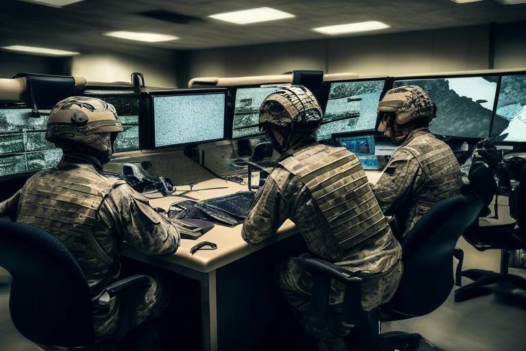
Effective communication is the backbone of any successful military operation. Satellites play a vital role in facilitating secure and reliable communication among coalition forces, ensuring seamless information exchange and decision-making during operations in various terrains and conditions. Imagine trying to coordinate a complex operation without the ability to communicate effectively; it would be like trying to conduct an orchestra without a conductor. Satellite communications allow for real-time updates and strategic adjustments, which are crucial when every second counts.
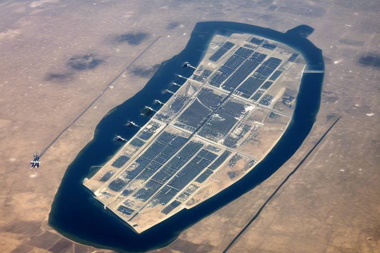
Utilizing advanced satellite technology, coalition forces can conduct real-time surveillance and reconnaissance, gathering crucial intelligence on enemy movements and terrain. This capability significantly enhances situational awareness and operational planning, allowing military leaders to make informed decisions based on accurate data. The value of having eyes in the sky cannot be overstated, as it provides a comprehensive picture of the battlefield that ground troops simply cannot achieve alone.
High-resolution satellite imagery provides coalition forces with detailed visual data, aiding in mission planning and target identification while reducing risks associated with ground reconnaissance. Think of it as having a bird's-eye view of the battlefield, where every detail can be scrutinized before troops move in. This imagery allows commanders to assess potential threats and opportunities, ensuring that they are always one step ahead.
Satellites can monitor changes in the environment, such as troop movements or infrastructure developments. This capability allows coalition forces to adapt strategies based on real-time information. For instance, if enemy troops are repositioning, satellites can quickly relay this information, enabling coalition forces to adjust their plans accordingly and maintain the upper hand.
In addition to military intelligence, satellites assist in assessing environmental conditions, providing vital data on weather patterns that can affect military operations and troop deployments. Bad weather can turn a well-laid plan into chaos, so having accurate forecasts and environmental assessments is essential for mission success.
Satellites are equipped to intercept and analyze communications from adversaries, providing coalition forces with valuable insights into enemy strategies and intentions. This form of intelligence gathering is akin to listening in on the enemy's playbook, allowing coalition forces to anticipate moves and counteract effectively.
Satellite navigation systems, such as GPS, are essential for coalition forces, enabling precise positioning and movement coordination, which is critical for mission success in complex operational environments. Without accurate navigation, troops could easily become disoriented, leading to disastrous consequences. Satellite technology ensures that every unit knows its position and can navigate safely through challenging terrains.
Satellites assist in route planning by providing real-time data on terrain and obstacles. This information ensures safe and efficient movement of troops and supplies. Imagine a group of soldiers trying to traverse a mountainous region without knowing where the steep cliffs or hidden ravines are; it would be perilous. Satellite data mitigates these risks, allowing for strategic planning that prioritizes safety and efficiency.
Satellite technology enables effective coordination among various coalition units, facilitating joint operations and enhancing overall mission effectiveness through shared situational awareness. In a multi-national effort, where forces from different countries work together, clear communication and coordination are paramount. Satellites serve as the glue that holds these efforts together, ensuring that all units are synchronized and working towards a common goal.
Satellites improve logistics and supply chain management for coalition forces, ensuring timely delivery of resources and equipment essential for sustaining operational readiness in the field. In military operations, the phrase "amateurs talk tactics, professionals talk logistics" rings true. The ability to track and manage supplies effectively can make or break a mission.
Through satellite tracking, coalition forces can monitor the location and status of supplies, optimizing resource allocation and minimizing delays during critical missions. This capability is akin to having a GPS for every piece of equipment, ensuring that nothing gets lost in transit.
Satellites aid in maintaining accurate inventory records, ensuring that coalition forces have the necessary supplies available when and where they are needed. Imagine preparing for a significant operation only to find out that essential supplies are missing; it could spell disaster. Satellite technology helps prevent such scenarios, ensuring that resources are always at the ready.
- How do satellites enhance communication in military operations? Satellites provide secure and reliable communication channels, allowing for real-time information exchange among coalition forces.
- What role do satellites play in surveillance? Satellites enable real-time surveillance and reconnaissance, offering vital intelligence on enemy movements and terrain.
- Why is navigation critical for coalition forces? Accurate navigation ensures that troops can move safely and efficiently through complex operational environments.
- How do satellites assist in logistics? Satellites improve logistics by enabling real-time tracking of supplies and maintaining accurate inventory records.
Communication Enhancement
In the ever-evolving landscape of modern warfare, communication stands as the backbone of operational success for coalition forces. Just imagine a scenario where troops are deployed in unfamiliar terrain, surrounded by potential threats. How do they maintain the lines of communication that are vital for survival and mission accomplishment? This is where satellites come into play, acting as the invisible threads that weave together the fabric of military coordination. By facilitating secure and reliable communication, satellites ensure that information flows seamlessly, allowing commanders to make informed decisions in real-time, regardless of the environment or conditions.
One of the standout features of satellite communication is its ability to transcend geographical barriers. Unlike traditional communication methods that can be hindered by terrain, weather, or enemy interference, satellite systems maintain a constant link. This capability is particularly crucial during joint operations where multiple forces from different nations collaborate. Coalition forces can share intelligence, relay orders, and coordinate movements without the fear of interception or disruption. The result? An impressive increase in operational efficiency and effectiveness.
Moreover, the integration of secure communication protocols ensures that sensitive information remains protected from prying eyes. As coalition forces engage in complex missions, the need for confidentiality and integrity in communication cannot be overstated. By utilizing encryption and advanced coding techniques, satellite communication systems provide a secure channel that minimizes the risk of data breaches. This not only safeguards military strategies but also protects the lives of personnel on the ground.
To illustrate the significance of satellite communication, consider the following table that highlights the key benefits:
| Benefit | Description |
|---|---|
| Global Coverage | Satellites provide communication links across vast distances, ensuring connectivity in remote areas. |
| Real-Time Communication | Instantaneous data transmission allows for quick decision-making and responsiveness during operations. |
| Secure Channels | Advanced encryption protects sensitive information from interception by adversaries. |
| Interoperability | Facilitates communication between different nations’ forces, enhancing collaboration in joint operations. |
In addition to these benefits, satellite communication systems are also equipped with capabilities that allow for multimedia transmission. This means that coalition forces can exchange not just text-based messages but also images, videos, and other critical data formats. Imagine a commander receiving live footage from a reconnaissance satellite while on the ground, enabling them to adjust strategies on the fly. This kind of real-time information exchange can be the difference between mission success and failure.
Furthermore, the resilience of satellite communication systems is noteworthy. In a world where electronic warfare is increasingly common, having a communication method that can withstand jamming and other forms of interference is paramount. Satellites are designed with redundancy and robustness, ensuring that even in the face of adversity, coalition forces can maintain their lines of communication.
In summary, the role of satellites in enhancing communication for coalition forces cannot be overstated. They provide a secure, reliable, and efficient means of communication that is crucial for operational success. As military operations grow more complex, the reliance on satellite technology will only continue to increase, shaping the future of warfare and collaboration among allied nations.
Surveillance and Reconnaissance
In today's complex battlefield, the ability to gather accurate and timely information is paramount for the success of military operations. This is where satellites come into play, providing coalition forces with an unparalleled edge in surveillance and reconnaissance. Imagine having a bird's-eye view of the entire operational theater, with the capability to monitor enemy movements and terrain conditions in real-time. This technological advantage not only enhances situational awareness but also informs critical decision-making processes.
Utilizing advanced satellite technology, coalition forces can conduct comprehensive surveillance missions that gather crucial intelligence about enemy activities. The integration of high-resolution satellite imagery allows military planners to visualize the battlefield like never before. This imagery is not just a collection of pictures; it is a treasure trove of information that aids in mission planning and target identification. By reducing the risks associated with ground reconnaissance, satellites offer a safer alternative to traditional methods, allowing forces to gather intelligence without exposing personnel to unnecessary danger.
The role of imagery intelligence cannot be overstated. High-resolution images captured by satellites provide detailed visual data, enabling military analysts to assess the battlefield's dynamics. For instance, if a coalition force needs to identify potential enemy positions, satellite imagery can reveal the layout of the terrain, the presence of fortifications, and even the number of troops stationed at a location. This information is essential for effective mission planning and can significantly reduce the risks associated with surprise attacks.
Satellites are also equipped with the ability to monitor changes in the environment, which can be critical during military operations. Through change detection capabilities, coalition forces can observe troop movements, infrastructure developments, and other significant alterations in the landscape. This real-time monitoring allows commanders to adapt their strategies swiftly, ensuring that they remain one step ahead of their adversaries. For example, if a satellite detects a sudden increase in enemy troop concentrations in a particular area, coalition forces can adjust their operational plans accordingly to mitigate potential threats.
In addition to monitoring enemy activities, satellites play a vital role in assessing environmental conditions. Environmental monitoring provides coalition forces with vital data on weather patterns, which can significantly impact military operations and troop deployments. Imagine planning a critical operation only to have it thwarted by unexpected weather changes. With satellite data, commanders can make informed decisions about when and where to deploy their forces, ensuring that they maximize their operational effectiveness.
Moreover, satellites are equipped to intercept and analyze communications from adversaries, providing coalition forces with valuable insights into enemy strategies and intentions. This aspect of signals intelligence is crucial for understanding the enemy's plans and countering them effectively. By monitoring communications, coalition forces can anticipate moves, disrupt enemy operations, and maintain the upper hand in the theater of war.
In conclusion, the integration of satellite technology into surveillance and reconnaissance operations has transformed the capabilities of coalition forces. With the ability to gather real-time intelligence, monitor environmental conditions, and intercept enemy communications, satellites have become indispensable tools in modern military strategy. As technology continues to evolve, the role of satellites in supporting coalition forces will only become more critical, ensuring that they remain prepared and agile in the face of emerging challenges.
- How do satellites improve military communication?
Satellites enable secure and reliable communication channels, allowing coalition forces to exchange information seamlessly in various terrains and conditions. - What is the importance of imagery intelligence?
Imagery intelligence provides detailed visual data that aids in mission planning and target identification, reducing risks associated with ground reconnaissance. - Can satellites monitor weather conditions?
Yes, satellites assist in assessing weather patterns, providing vital data that can affect military operations and troop deployments. - How do satellites contribute to logistics management?
Satellites enhance logistics by allowing real-time tracking of supplies and maintaining accurate inventory records, ensuring timely delivery of resources.
Imagery Intelligence
is a game-changer for coalition forces, offering a bird's-eye view of the battlefield that traditional reconnaissance methods simply cannot match. Imagine having the ability to see vast areas of land in stunning detail from space—this is the power that high-resolution satellite imagery brings to military operations. With the click of a button, commanders can access detailed visual data that enhances mission planning and target identification, ultimately reducing risks associated with ground reconnaissance missions.
The advantages of satellite imagery go beyond just pretty pictures. High-resolution images can reveal crucial information such as troop concentrations, supply routes, and even the type of terrain that forces might encounter. This level of detail is invaluable when planning operations in unfamiliar territories. For instance, if a coalition force is preparing to launch an offensive, they can analyze satellite images to identify potential ambush points or safe zones, allowing them to devise strategies that maximize their chances of success.
But wait, there's more! Satellites are not just static observers; they can continuously monitor changes in the environment. This change detection capability allows coalition forces to adapt their strategies based on real-time information. For example, if satellite imagery reveals the sudden movement of enemy troops or the construction of new defensive structures, commanders can quickly reassess their plans and make informed decisions. This adaptability is crucial in modern warfare, where the situation on the ground can change in an instant.
Moreover, satellites also play a significant role in environmental monitoring. They provide vital data on weather patterns, which can significantly affect military operations and troop deployments. For instance, if a storm is brewing over a planned operation area, satellite data can alert commanders to potential weather-related disruptions, allowing them to adjust their timelines and strategies accordingly. In essence, the integration of imagery intelligence into military operations not only enhances situational awareness but also empowers coalition forces to act swiftly and decisively.
| Type of Imagery | Purpose | Benefits |
|---|---|---|
| High-Resolution | Mission Planning | Detailed visual data for target identification |
| Change Detection | Real-Time Adaptation | Quick reassessment based on enemy movements |
| Environmental Monitoring | Weather Forecasting | Informed decision-making regarding troop deployments |
In summary, imagery intelligence serves as a cornerstone of modern military strategy. By leveraging the advanced capabilities of satellite technology, coalition forces can gain a comprehensive understanding of the operational landscape, leading to better decision-making and ultimately, mission success. The fusion of high-resolution imaging, change detection, and environmental monitoring creates an unparalleled advantage on the battlefield, allowing coalition forces to stay one step ahead of their adversaries.
- What is imagery intelligence? - Imagery intelligence involves the use of satellite imagery to gather detailed visual data for military operations, enhancing situational awareness and mission planning.
- How does change detection work? - Change detection utilizes satellite technology to monitor and identify changes in the environment, such as troop movements or new infrastructure, allowing for real-time strategic adaptations.
- Why is environmental monitoring important? - Environmental monitoring provides critical data on weather patterns, helping military planners make informed decisions regarding troop deployments and operational timelines.
Change Detection
Change detection is a crucial aspect of military operations, particularly for coalition forces operating in dynamic environments. By leveraging advanced satellite technology, these forces can monitor and identify changes in the battlefield landscape in real-time. This capability is akin to having a bird's-eye view of the operational theater, allowing commanders to adapt their strategies swiftly and effectively. Imagine trying to navigate through a dense forest; without the right tools, you could easily get lost. Now, picture having a high-tech drone guiding you with precise updates about every twist and turn. That's exactly what satellites provide to military strategists on the ground.
With the ability to detect changes such as troop movements, infrastructure developments, and even environmental alterations, coalition forces can make informed decisions that significantly enhance their operational effectiveness. For instance, if a satellite detects an unexpected buildup of enemy troops in a particular area, commanders can quickly redirect their forces or adjust their tactics to counter the threat. This level of situational awareness is vital for maintaining the upper hand in any military engagement.
Moreover, satellites can monitor changes over time, allowing for trend analysis that can reveal patterns in enemy behavior. This is particularly useful for anticipating potential threats and preparing countermeasures in advance. The data collected can be presented in various formats, including high-resolution images and 3D terrain models, which can be invaluable during mission planning and execution.
| Change Detected | Implications for Coalition Forces |
|---|---|
| Troop Movements | Adjust tactics and reposition forces |
| Infrastructure Developments | Assess enemy capabilities and plan accordingly |
| Environmental Changes | Adapt operations based on weather and terrain |
In conclusion, the role of satellites in change detection cannot be overstated. They provide coalition forces with the necessary tools to remain agile and responsive in the face of evolving challenges on the battlefield. By continuously monitoring the environment and detecting changes, these forces can ensure that they are always one step ahead of their adversaries, ultimately leading to more successful operations.
- What is change detection in military operations? Change detection refers to the process of identifying and analyzing changes in the battlefield environment, such as troop movements or infrastructure developments, through satellite imagery and data.
- How do satellites aid in change detection? Satellites provide real-time and high-resolution imagery that allows military forces to monitor changes and make informed decisions quickly.
- Why is change detection important for coalition forces? It enhances situational awareness, allowing for timely strategic adjustments that can impact the success of military operations.
Environmental Monitoring
In the realm of military operations, understanding the environment is as crucial as knowing the enemy. through satellite technology provides coalition forces with the ability to assess various factors that can significantly impact their missions. Imagine trying to navigate a dense forest without knowing the weather conditions—it's a recipe for disaster. Similarly, military operations can falter without accurate environmental data.
Satellites equipped with advanced sensors can monitor a variety of environmental conditions, including weather patterns, temperature fluctuations, and even natural disasters. This information is vital for planning troop movements and ensuring the safety of personnel in the field. For instance, if a satellite detects an impending storm, commanders can adjust their strategies to avoid exposing troops to hazardous conditions, thereby enhancing operational effectiveness.
Moreover, satellite data can inform coalition forces about geographical changes that may affect their operations. For example, if reconnaissance satellites identify flooding in a specific area, forces can reroute their supply lines or adjust their operational tactics to ensure they remain effective and safe. This adaptability is essential in dynamic combat environments, where conditions can change rapidly.
To illustrate the importance of environmental monitoring, consider the following table that outlines the types of data satellites can provide:
| Type of Data | Description | Impact on Operations |
|---|---|---|
| Weather Conditions | Real-time updates on temperature, precipitation, and wind patterns. | Informs troop movements and operational planning. |
| Geographical Changes | Data on land alterations due to natural disasters or human activities. | Affects route planning and logistics. |
| Natural Disasters | Detection of events like earthquakes, floods, or wildfires. | Ensures the safety of troops and civilians, and aids in disaster response. |
In conclusion, the role of satellites in cannot be overstated. They provide coalition forces with the critical information needed to make informed decisions, adapt to changing conditions, and ultimately ensure mission success. By leveraging satellite technology, military leaders can turn potential challenges into opportunities, enhancing their operational capabilities on the battlefield.
- What types of satellites are used for environmental monitoring?
Various types of satellites are utilized, including weather satellites, reconnaissance satellites, and Earth observation satellites, each designed to gather specific types of data.
- How often is environmental data updated?
Data can be updated in real-time or at regular intervals, depending on the satellite's capabilities and the specific operational needs of the coalition forces.
- Can environmental monitoring help in disaster relief operations?
Absolutely! Satellite data can guide disaster response efforts by providing critical information about affected areas, enabling timely and effective relief actions.
Signals Intelligence
Signals Intelligence (SIGINT) is a game changer in modern warfare, acting as the eyes and ears of coalition forces. Imagine being able to listen in on your adversaries' conversations, intercept their communications, and gather critical information without them even knowing. This is precisely what satellites equipped with advanced SIGINT capabilities can do. By capturing electronic signals, coalition forces gain invaluable insights into enemy strategies, troop movements, and operational intentions. The ability to monitor these signals can dramatically shift the balance of power on the battlefield.
One of the most fascinating aspects of SIGINT is its ability to provide a comprehensive picture of the operational environment. Coalition forces can analyze intercepted communications to identify patterns, understand enemy capabilities, and even predict future actions. This level of intelligence is akin to having a strategic playbook of the opposition, allowing for proactive decision-making rather than reactive responses. With the right data, military leaders can adapt their strategies in real-time, ensuring that they stay one step ahead of their adversaries.
Moreover, SIGINT is not just about intercepting voice communications. It encompasses a wide range of electronic signals, including:
- Radio Communications: These are crucial for understanding the immediate tactical situation.
- Data Links: Used for various military applications, including drone operations and troop coordination.
- Radar Signals: Essential for detecting enemy movements and understanding their capabilities.
By leveraging satellite technology, coalition forces can enhance their SIGINT capabilities significantly. Satellites can cover vast geographical areas, providing a broader scope for intelligence gathering. This capability is especially vital in regions where ground-based intelligence is limited or risky. With real-time data at their fingertips, military units can make informed decisions about troop deployments, resource allocations, and engagement strategies.
Furthermore, the integration of artificial intelligence (AI) into SIGINT analysis is revolutionizing how data is processed and interpreted. AI can sift through enormous amounts of intercepted data, identifying relevant signals and patterns that human analysts might overlook. This synergy between satellite technology and AI not only speeds up the intelligence-gathering process but also enhances accuracy, providing coalition forces with a reliable foundation for their operations.
In conclusion, Signals Intelligence, powered by satellite technology, is an indispensable asset for coalition forces. It transforms raw electronic signals into actionable intelligence, shaping the course of military operations. As technology continues to evolve, the role of SIGINT will only become more crucial in maintaining operational superiority and ensuring mission success.
- What is Signals Intelligence (SIGINT)? SIGINT is the interception and analysis of electronic signals to gather intelligence about enemy activities and intentions.
- How do satellites contribute to SIGINT? Satellites can intercept a wide range of electronic signals over large areas, providing real-time intelligence that enhances situational awareness.
- What types of communications can be intercepted? SIGINT can include radio communications, data links, and radar signals, among others.
- How is AI used in SIGINT? AI helps process and analyze large volumes of intercepted data, identifying patterns and relevant information more efficiently than human analysts alone.
Navigation and Positioning
In the realm of military operations, precision is not just a luxury; it’s a necessity. This is where satellite navigation systems come into play, particularly GPS (Global Positioning System). Imagine trying to navigate a complex maze without a map or a guide. It would be chaotic, right? Similarly, coalition forces rely heavily on satellites to provide accurate positioning and movement coordination, which is vital for mission success, especially in complex operational environments.
Satellites enable coalition forces to determine their exact location on the globe, which is crucial for planning and executing operations. Without this capability, troops could easily become disoriented or lost, leading to disastrous consequences. The precision offered by satellite navigation allows for meticulous planning and execution of maneuvers. For instance, when troops are deployed in unfamiliar terrain, satellite systems can provide them with real-time data, ensuring they stay on course and avoid potential hazards.
Moreover, satellite systems are not just about knowing where troops are; they also facilitate effective route planning. By analyzing terrain data and identifying obstacles, satellites help commanders devise the safest and most efficient routes for troop movements. This is especially important in hostile environments where enemy forces may be lurking. Just think of it as having a personal GPS that not only tells you where to go but also helps you navigate through the safest paths available.
In addition to route planning, satellite technology significantly enhances joint operations coordination. Coalition forces often consist of various military branches and units, each with its own objectives and strategies. Satellites ensure that all units have access to shared situational awareness, allowing them to coordinate their actions seamlessly. This is akin to a well-rehearsed orchestra, where each musician knows their part and plays in harmony with others. When everyone is on the same page, the effectiveness of the overall mission is drastically improved.
To illustrate the impact of satellite navigation on military operations, consider the following table that highlights key benefits:
| Benefit | Description |
|---|---|
| Precision Positioning | Enables accurate location tracking for troops and equipment. |
| Route Optimization | Facilitates the planning of safe and efficient movement paths. |
| Joint Coordination | Enhances collaboration among different units and branches. |
| Real-Time Updates | Provides instantaneous data on troop movements and environmental changes. |
In conclusion, the role of satellites in navigation and positioning cannot be overstated. They transform the chaotic nature of military operations into a well-orchestrated effort, where every movement is calculated and every decision is informed. As technology continues to advance, the reliance on satellite systems will only deepen, further enhancing the operational capabilities of coalition forces.
- How do satellites improve military navigation?
Satellites provide accurate positioning data, allowing military forces to navigate complex terrains effectively. - What is the significance of GPS in military operations?
GPS enables precise route planning and movement coordination, which are critical for mission success. - Can satellites assist in joint military operations?
Yes, satellite technology facilitates real-time communication and situational awareness among different military units, enhancing coordination.
Route Planning
When it comes to military operations, effective can make the difference between success and failure. Coalition forces rely heavily on satellite technology to ensure that their movements are not only efficient but also safe. Imagine trying to navigate through a dense forest or a hostile urban environment without a clear map or guidance—it's a recipe for disaster! With satellites, however, troops can access real-time data that provides a comprehensive view of the terrain, helping them identify the safest and most effective routes.
One of the key advantages of satellite-assisted route planning is the ability to analyze various factors that could impact movement. These include:
- Terrain Features: Satellites provide detailed topographical maps that highlight hills, valleys, rivers, and other natural obstacles.
- Weather Conditions: Real-time weather data from satellites helps forces avoid areas prone to adverse conditions, such as heavy rain or snow, which could slow down their progress.
- Enemy Presence: Continuous surveillance allows coalition forces to detect enemy movements along potential routes, enabling them to adjust their plans accordingly.
Moreover, satellite technology enhances coordination among different units. For instance, when multiple coalition forces are operating in close proximity, they can share route information instantly, ensuring that everyone is on the same page. This shared situational awareness minimizes the risk of friendly fire and increases the overall effectiveness of the operation.
To illustrate the impact of satellite-assisted route planning, consider the following table that compares traditional navigation methods with satellite-based systems:
| Aspect | Traditional Navigation | Satellite Navigation |
|---|---|---|
| Data Availability | Limited and often outdated | Real-time and constantly updated |
| Accuracy | Subject to human error | Highly precise with GPS technology |
| Adaptability | Slow to adjust to changing conditions | Instant adjustments based on live data |
| Communication | Dependent on ground-based systems | Global coverage with satellite links |
In conclusion, supported by satellite technology is crucial for the operational success of coalition forces. By leveraging real-time data, troops can navigate complex environments more effectively, adapt to changing conditions, and ultimately enhance mission success rates. It’s like having a high-tech compass that not only points the way but also warns you of potential dangers ahead!
- How do satellites improve route planning for military operations? Satellites provide real-time data on terrain, weather, and enemy movements, enabling troops to choose the safest and most efficient routes.
- What are the risks of not using satellite technology in route planning? Without satellite assistance, troops may encounter unexpected obstacles, face adverse weather conditions, or even run into enemy forces, leading to mission failure.
- Can satellite navigation systems be used in urban environments? Absolutely! Satellite navigation systems are effective in various terrains, including urban areas, where they can help navigate complex street layouts.
Joint Operations Coordination
This article explores how satellites enhance the operational capabilities of coalition forces, providing critical support in communication, surveillance, navigation, and coordination during military operations.
Satellites play a vital role in facilitating secure and reliable communication among coalition forces, ensuring seamless information exchange and decision-making during operations in various terrains and conditions.
Utilizing advanced satellite technology, coalition forces can conduct real-time surveillance and reconnaissance, gathering crucial intelligence on enemy movements and terrain, which enhances situational awareness and operational planning.
High-resolution satellite imagery provides coalition forces with detailed visual data, aiding in mission planning and target identification while reducing risks associated with ground reconnaissance.
Satellites can monitor changes in the environment, such as troop movements or infrastructure developments, allowing coalition forces to adapt strategies based on real-time information.
Satellites assist in assessing environmental conditions, providing vital data on weather patterns that can affect military operations and troop deployments.
Satellites are equipped to intercept and analyze communications from adversaries, providing coalition forces with valuable insights into enemy strategies and intentions.
Satellite navigation systems, such as GPS, are essential for coalition forces, enabling precise positioning and movement coordination, which is critical for mission success in complex operational environments.
Satellites assist in route planning by providing real-time data on terrain and obstacles, ensuring safe and efficient movement of troops and supplies.
In the heat of military operations, coordination among various coalition units can be the make-or-break factor for mission success. Satellite technology plays an indispensable role in this intricate dance of joint operations. Imagine a conductor leading an orchestra; each musician must be in sync to create a harmonious performance. Similarly, coalition forces rely on satellites to ensure that every unit is informed, aligned, and ready to act.
Through the use of satellite communication systems, coalition forces can share real-time data, including troop positions, mission updates, and strategic changes. This capability is especially crucial in dynamic environments where situations can shift rapidly. For example, if a unit encounters unexpected resistance, they can immediately relay this information to other forces via satellite links, allowing for swift adjustments in strategy.
Furthermore, satellite technology enhances operational planning by providing a comprehensive overview of the battlefield. Coalition commanders can visualize troop movements and logistical needs on a digital map, enabling them to make informed decisions. The ability to monitor the entire operational landscape from a bird’s-eye view is akin to having a tactical advantage that can significantly influence the outcome of missions.
Moreover, the integration of satellite data with ground intelligence fosters a unified approach to mission execution. This synergy allows for:
- Improved situational awareness: All units have access to the same information, reducing the chances of miscommunication.
- Enhanced tactical flexibility: Forces can adapt to changing conditions and respond to threats more effectively.
- Streamlined resource allocation: Commanders can better allocate assets where they are needed most, optimizing operational efficiency.
In essence, joint operations coordination powered by satellite technology transforms disparate forces into a cohesive unit, capable of executing complex missions with precision and agility.
Satellites improve logistics and supply chain management for coalition forces, ensuring timely delivery of resources and equipment essential for sustaining operational readiness in the field.
Through satellite tracking, coalition forces can monitor the location and status of supplies, optimizing resource allocation and minimizing delays during critical missions.
Satellites aid in maintaining accurate inventory records, ensuring that coalition forces have the necessary supplies available when and where they are needed.
- How do satellites improve communication among coalition forces?
Satellites provide secure and reliable communication channels, allowing for real-time information exchange and coordination across various operational areas.
- What role do satellites play in surveillance?
Satellites enable real-time surveillance and reconnaissance, offering high-resolution imagery and monitoring changes in enemy movements, which enhances situational awareness.
- How do coalition forces utilize satellite navigation?
Satellite navigation systems, like GPS, allow for precise positioning and route planning, critical for mission success in complex environments.
- Can satellites assist in logistics and supply chain management?
Yes, satellites facilitate real-time tracking of supplies and inventory management, ensuring that resources are delivered efficiently and on time.
Logistics and Supply Chain Management
In the fast-paced world of military operations, the importance of cannot be overstated. Coalition forces rely heavily on effective logistics to ensure they are always ready to respond to emerging threats. Imagine trying to conduct a military operation without the right supplies—it's like trying to bake a cake without any ingredients! This is where satellite technology comes into play, revolutionizing how resources are managed and delivered in the field.
Satellites improve logistics by providing real-time data that helps commanders make informed decisions regarding supply routes and inventory levels. With the ability to track supplies from their point of origin to their final destination, coalition forces can ensure that troops have what they need, when they need it. This capability is particularly crucial in hostile environments where traditional communication methods may be compromised.
One of the key advantages of satellite technology is real-time tracking. Through advanced tracking systems, coalition forces can monitor the location and status of supplies, ensuring that resources are allocated efficiently. For instance, if a unit is running low on ammunition, satellite data can quickly identify the nearest supply depot and facilitate a timely resupply mission. This not only minimizes delays but also enhances the operational readiness of the troops.
Moreover, accurate inventory management is another critical aspect of logistics that satellites enhance. By maintaining precise records of available supplies, coalition forces can avoid overstocking or understocking essential items. This is akin to having a well-organized pantry at home; when you know what you have, you can cook efficiently without running out of ingredients. In military terms, this means that when troops are deployed, they can focus on their mission rather than worrying about whether they have enough food, fuel, or medical supplies.
| Logistics Benefits of Satellite Technology | Description |
|---|---|
| Real-Time Tracking | Allows monitoring of supply movements, ensuring timely delivery and optimal resource allocation. |
| Accurate Inventory Management | Helps maintain precise records of supplies, preventing shortages and excesses. |
| Route Optimization | Enables efficient planning of supply routes, avoiding obstacles and hazards. |
In conclusion, the role of satellites in logistics and supply chain management for coalition forces is invaluable. They not only streamline operations but also enhance the overall effectiveness of military missions. By leveraging satellite technology, coalition forces can ensure that their troops are well-equipped and ready to face any challenge, making logistics a cornerstone of successful military operations.
- How do satellites improve logistics for military operations? Satellites provide real-time tracking and inventory management, enabling efficient resource allocation and timely deliveries.
- What is the importance of accurate inventory management in military logistics? Accurate inventory management prevents shortages and excesses, ensuring that troops have the necessary supplies when needed.
- Can satellite technology enhance route planning for supply deliveries? Yes, satellites can provide crucial data on terrain and obstacles, optimizing supply routes for safety and efficiency.
Real-Time Tracking
This article explores how satellites enhance the operational capabilities of coalition forces, providing critical support in communication, surveillance, navigation, and coordination during military operations.
Satellites play a vital role in facilitating secure and reliable communication among coalition forces, ensuring seamless information exchange and decision-making during operations in various terrains and conditions.
Utilizing advanced satellite technology, coalition forces can conduct real-time surveillance and reconnaissance, gathering crucial intelligence on enemy movements and terrain, which enhances situational awareness and operational planning.
High-resolution satellite imagery provides coalition forces with detailed visual data, aiding in mission planning and target identification while reducing risks associated with ground reconnaissance.
Satellites can monitor changes in the environment, such as troop movements or infrastructure developments, allowing coalition forces to adapt strategies based on real-time information.
Satellites assist in assessing environmental conditions, providing vital data on weather patterns that can affect military operations and troop deployments.
Satellites are equipped to intercept and analyze communications from adversaries, providing coalition forces with valuable insights into enemy strategies and intentions.
Satellite navigation systems, such as GPS, are essential for coalition forces, enabling precise positioning and movement coordination, which is critical for mission success in complex operational environments.
Satellites assist in route planning by providing real-time data on terrain and obstacles, ensuring safe and efficient movement of troops and supplies.
Satellite technology enables effective coordination among various coalition units, facilitating joint operations and enhancing overall mission effectiveness through shared situational awareness.
Satellites improve logistics and supply chain management for coalition forces, ensuring timely delivery of resources and equipment essential for sustaining operational readiness in the field.
In the fast-paced world of military operations, through satellite technology has become a game changer. Imagine being in a vast desert or dense forest, where every second counts, and the right supplies can make all the difference. With satellite tracking, coalition forces can monitor the precise location and status of their supplies at any given moment, ensuring that they are not just aware of what they have, but also where it is. This capability allows for an optimized allocation of resources, minimizing delays and enhancing the overall efficiency of operations.
For instance, consider a scenario where troops are engaged in a critical mission. Real-time tracking enables commanders to see if reinforcements or supplies are on schedule, or if they need to adjust their plans. This dynamic visibility can be the difference between success and failure in high-stakes environments. Furthermore, the data collected through satellite tracking can be analyzed to improve future logistics strategies, creating a feedback loop that continually enhances operational effectiveness.
Moreover, the integration of satellite tracking systems with existing logistics frameworks ensures that coalition forces can respond swiftly to any changes on the ground. Whether it's redirecting supplies due to unexpected enemy movements or adjusting delivery routes based on real-time intelligence, the agility provided by satellite technology is indispensable. In essence, real-time tracking not only keeps the supply chain fluid but also fortifies the operational backbone of coalition forces.
- How do satellites improve communication among coalition forces?
Satellites facilitate secure and reliable communication channels that ensure seamless information exchange, crucial for decision-making in various terrains. - What role do satellites play in surveillance?
Satellites enable real-time surveillance and reconnaissance, providing vital intelligence on enemy movements and environmental conditions. - How does satellite navigation assist military operations?
Satellite navigation systems like GPS provide precise positioning and movement coordination, essential for mission success in complex environments. - What is the significance of real-time tracking?
Real-time tracking allows coalition forces to monitor supply locations and statuses, optimizing resource allocation and minimizing delays during critical missions.
Inventory Management
In the fast-paced world of military operations, is not just a logistical concern; it's a critical component that can determine the success or failure of a mission. Coalition forces rely heavily on satellite technology to maintain a comprehensive overview of their supplies, ensuring that every piece of equipment and every resource is accounted for. Imagine trying to conduct a complex operation while worrying about whether your troops have enough ammunition or medical supplies. This is where satellites come into play, revolutionizing how inventory is managed.
Through satellite systems, coalition forces can track the movement and status of supplies in real-time. This capability allows for quick adjustments to be made when necessary, ensuring that resources are allocated efficiently and effectively. For instance, if a particular unit is running low on critical supplies, commanders can quickly reroute resources from other areas, significantly reducing the risk of delays during operations. The ability to monitor inventory levels remotely means that decisions can be made swiftly, enhancing operational readiness and responsiveness.
Furthermore, satellites provide detailed data that helps in maintaining accurate inventory records. This data includes information about stock levels, usage rates, and even the condition of supplies. By continuously monitoring these factors, coalition forces can predict when they will need to replenish certain items, avoiding the dreaded scenario of running out of essential resources in the field. It’s like having a personal assistant who not only keeps track of what you have but also reminds you when it’s time to restock!
To illustrate the effectiveness of satellite-assisted inventory management, consider the following table:
| Inventory Item | Current Stock Level | Reorder Point | Status |
|---|---|---|---|
| Ammunition | 2,000 rounds | 1,500 rounds | In Stock |
| Medical Supplies | 150 kits | 100 kits | In Stock |
| Fuel | 5,000 liters | 3,000 liters | In Stock |
| Food Rations | 2,500 packs | 2,000 packs | Low Stock |
This table highlights how satellite technology can help coalition forces maintain a clear picture of their inventory, allowing for proactive management rather than reactive measures. In the heat of battle, every second counts, and having the right supplies at the right time can make all the difference.
Ultimately, the integration of satellite technology into inventory management systems not only streamlines operations but also enhances the overall effectiveness of coalition forces. By ensuring that every soldier has the necessary supplies at their fingertips, military leaders can focus on what truly matters: executing their mission and achieving their objectives.
- How do satellites improve inventory management in military operations?
Satellites provide real-time tracking and monitoring of supplies, allowing for efficient resource allocation and timely replenishment of essential items. - What are the benefits of using satellite technology for logistics?
Satellite technology enhances situational awareness, reduces delays, and ensures that troops have access to the supplies they need when they need them. - Can satellite data help predict inventory needs?
Yes, continuous monitoring of inventory levels and usage rates through satellite data allows for accurate predictions of when supplies need to be restocked.
Frequently Asked Questions
- How do satellites enhance communication among coalition forces?
Satellites provide a secure and reliable means of communication, allowing coalition forces to exchange information seamlessly. This is crucial for decision-making during operations, especially in challenging terrains and conditions where traditional communication methods may fail.
- What role do satellites play in surveillance and reconnaissance?
Satellites enable real-time surveillance and reconnaissance, allowing coalition forces to gather vital intelligence on enemy movements and terrain. This enhances situational awareness, aiding in mission planning and execution.
- How does imagery intelligence from satellites benefit military operations?
High-resolution satellite imagery provides detailed visual data, which helps in mission planning and target identification. This reduces the risks associated with ground reconnaissance, ensuring safer operations.
- What is change detection, and why is it important?
Change detection involves monitoring environmental changes, such as troop movements or infrastructure developments. This allows coalition forces to adapt their strategies based on real-time information, ensuring they remain one step ahead of the enemy.
- Can satellites assist in environmental monitoring?
Absolutely! Satellites provide vital data on weather patterns and environmental conditions, which can significantly impact military operations and troop deployments.
- How do satellites contribute to navigation and positioning?
Satellite navigation systems like GPS enable precise positioning and movement coordination, which are essential for mission success in complex operational environments.
- What is the significance of route planning using satellite technology?
Satellites provide real-time data on terrain and obstacles, assisting in route planning. This ensures the safe and efficient movement of troops and supplies, which is crucial during missions.
- How do satellites facilitate joint operations coordination?
Satellite technology enhances coordination among various coalition units, allowing for effective joint operations and improving overall mission effectiveness through shared situational awareness.
- In what ways do satellites improve logistics and supply chain management?
Satellites enable real-time tracking of supplies, optimizing resource allocation and minimizing delays. They also assist in maintaining accurate inventory records, ensuring that coalition forces have the necessary resources available when needed.
- How does real-time tracking benefit coalition forces?
Through satellite tracking, coalition forces can monitor the location and status of supplies, which is vital for ensuring timely delivery and operational readiness during critical missions.