How Drones Are Assisting in Volcanic Monitoring and Research
In recent years, the advent of drone technology has revolutionized the way we approach volcanic monitoring and research. Imagine being able to fly above a rumbling volcano, capturing stunning aerial imagery and gathering crucial data without putting human lives at risk. That's not just a dream anymore; it's a reality! Drones are now at the forefront of volcanic research, offering innovative solutions that enhance safety, improve data collection, and allow scientists to analyze volcanic activity like never before.
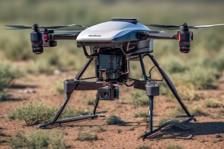
Drones equipped with cutting-edge technology can hover over hazardous areas, providing real-time insights into volcanic behavior. This means researchers can observe changes in volcanic activity from a safe distance while still gathering essential information. With the ability to capture high-resolution images and collect data on gas emissions and thermal activity, drones are transforming the way scientists study volcanoes. Gone are the days when researchers had to rely solely on ground-based observations or risky fieldwork. Now, they can harness the power of drones to delve deeper into the mysteries of these natural wonders.
Moreover, the efficiency of drones in volcanic monitoring cannot be overstated. Traditional methods often involve extensive manpower, expensive equipment, and considerable time commitments. In contrast, drones can be deployed quickly and cost-effectively, allowing researchers to cover vast areas in a fraction of the time. This not only saves resources but also provides timely data that can be critical in assessing potential hazards and making informed decisions about public safety.
As we look to the future, the possibilities for drone technology in volcanic research are endless. With advancements in autonomous flight capabilities and enhanced sensors, we can expect even more sophisticated tools that will further improve our understanding of volcanic systems. The integration of artificial intelligence and machine learning into drone operations could lead to predictive models that help anticipate eruptions and mitigate risks to communities living near volcanoes.
In summary, drones are not just gadgets; they are powerful allies in the quest to understand and monitor volcanic activity. By combining cutting-edge technology with innovative research methods, we are entering a new era of volcanology that promises to enhance our safety and deepen our understanding of these awe-inspiring natural phenomena.
- How do drones improve safety in volcanic research?
Drones allow researchers to gather data from a safe distance, minimizing their exposure to hazardous volcanic environments. - What types of data can drones collect?
Drones can capture high-resolution images, monitor gas emissions, and detect thermal changes in volcanic areas. - Are drones more cost-effective than traditional monitoring methods?
Yes, drones can be deployed quickly and require less manpower and equipment, making them a more economical option for researchers. - What advancements can we expect in the future for drones in volcanology?
Future developments may include autonomous flight capabilities, enhanced sensors, and improved data analysis techniques that will revolutionize volcanic research.
The Role of Drones in Volcanic Monitoring
Drones have become an essential tool in the field of volcanic monitoring, revolutionizing how scientists observe and assess volcanic activity. Traditionally, monitoring a volcano required extensive ground-based equipment and often placed researchers in perilous situations. However, with the advent of drone technology, the landscape of volcanic research has undergone a significant transformation. These aerial devices enable researchers to gather real-time data, capture high-resolution imagery, and conduct assessments from a safe distance, all while minimizing risks to human life.
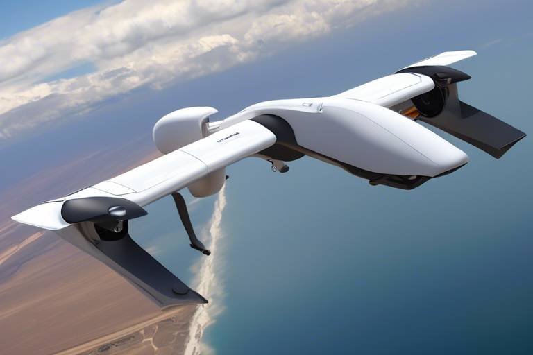
One of the most striking advantages of using drones is their ability to cover vast and often inaccessible areas. Volcanoes can be located in remote regions, surrounded by rugged terrain or hazardous conditions that make it nearly impossible for scientists to conduct traditional monitoring. Drones can effortlessly navigate these challenging environments, allowing for comprehensive data collection without the need for researchers to physically enter dangerous zones. This capability not only enhances data quality but also significantly boosts safety for those involved in the research.
Furthermore, drones are equipped with a variety of advanced sensors that enhance their monitoring capabilities. For instance, they can be outfitted with thermal cameras to detect heat signatures, providing insights into temperature fluctuations that may indicate volcanic activity. Additionally, drones can carry gas sensors that measure emissions of volcanic gases like sulfur dioxide, which are critical indicators of a volcano's behavior. This multi-faceted approach to data collection allows scientists to build a more comprehensive understanding of volcanic systems and their potential hazards.
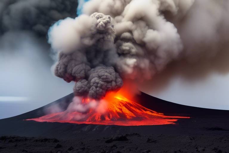
In essence, drones serve as the eyes in the sky, providing a bird’s-eye view of volcanic landscapes that was previously unattainable. They facilitate the monitoring of eruptions, lava flows, and ash dispersal patterns, which are crucial for not only scientific research but also for the safety of nearby communities. As the technology continues to evolve, the role of drones in volcanic monitoring is expected to expand even further, paving the way for more sophisticated and effective research methodologies.
In summary, the integration of drones into volcanic monitoring is a game-changer. By combining safety with advanced data collection techniques, these aerial devices are helping researchers unlock the mysteries of volcanoes while ensuring that human safety remains a top priority. As we look to the future, it’s exciting to think about how these innovations will continue to shape our understanding of volcanic activity and improve our ability to respond to potential threats.
Advantages of Using Drones Over Traditional Methods
When it comes to monitoring volcanoes, the traditional methods can often feel like trying to navigate a maze blindfolded. Enter drones, the game-changers in volcanic research! These high-tech marvels not only enhance safety but also bring a plethora of advantages that make them the go-to choice for researchers. Imagine having a bird's-eye view of a volcano, capturing detailed data without putting anyone in harm's way. That's the magic of drones!
One of the most significant benefits of using drones is their ability to access remote and hazardous areas that are often unreachable by traditional methods. Think about it: when scientists want to study a volcano, they usually have to trek through treacherous terrains, risking their lives just to gather data. With drones, this risk is substantially minimized. They can fly over dangerous zones, capturing images and data that would otherwise be impossible to obtain. This not only keeps researchers safe but also allows them to focus on what they do best—analyzing data and drawing conclusions.
Moreover, drones are cost-effective. Traditional monitoring methods often require extensive manpower, expensive equipment, and sometimes even helicopters for aerial surveys. Drones, on the other hand, can be operated by a small team and require significantly less financial investment. This cost reduction means that more resources can be allocated to research and analysis, ultimately leading to better science.
Another compelling advantage lies in the real-time data collection capabilities of drones. With advanced sensors and imaging technologies, drones can gather and transmit data on volcanic activity almost instantaneously. This real-time feedback is crucial during an eruption, as it allows scientists to monitor changes and make informed decisions quickly. For example, if a drone detects an increase in gas emissions or thermal activity, researchers can immediately assess the situation and alert local communities, potentially saving lives.
To illustrate these advantages further, consider the following table that compares drones to traditional methods:
| Feature | Drones | Traditional Methods |
|---|---|---|
| Safety | Minimal risk to human life | High risk, often requires direct human presence |
| Cost | Lower operational costs | Higher costs due to manpower and equipment |
| Data Collection | Real-time, high-resolution data | Delayed data collection, often less detailed |
| Accessibility | Can reach remote and hazardous areas | Limited access to dangerous locations |
In summary, the advantages of using drones in volcanic monitoring are clear. They not only enhance safety and reduce costs but also provide researchers with the ability to gather high-quality data in real-time. As technology continues to evolve, it’s exciting to think about how drones will further revolutionize the field of volcanology, making our understanding of these powerful natural phenomena more profound than ever before.
- How do drones collect data in volcanic environments?
Drones are equipped with advanced sensors and imaging technology that allow them to gather data on gas emissions, thermal activity, and topographical changes. - Are drones safe to use near active volcanoes?
Yes, drones are designed to operate in hazardous environments, significantly reducing the risk to human life while still allowing for effective monitoring. - What are the cost implications of using drones for volcanic research?
Drones are generally more cost-effective than traditional methods, as they require less manpower and equipment, allowing for better allocation of research funds.
Enhanced Data Collection Techniques
Drones have revolutionized the way we collect data in volcanic environments, providing researchers with a treasure trove of information that was previously difficult, if not impossible, to gather. Equipped with advanced sensors and imaging technology, these flying marvels are capable of capturing a wide array of data that enhances our understanding of volcanic behavior. Imagine being able to fly over a volcano and gather real-time data without putting anyone in harm's way—this is the power of drones!
One of the most significant advantages of drone technology is its ability to collect data on gas emissions, thermal activity, and topographical changes. For instance, drones outfitted with thermal imaging cameras can detect subtle temperature variations across the volcanic landscape. This capability is crucial because even slight changes in temperature can indicate potential volcanic activity, allowing scientists to act swiftly and effectively. In addition, drones can capture high-resolution imagery that provides detailed visual insights into the structure and changes of volcanic formations over time.
Furthermore, drones equipped with gas sensors can measure the concentration of various volcanic gases, such as sulfur dioxide (SO2) and carbon dioxide (CO2). These gases are essential indicators of volcanic activity; an increase in gas emissions can signal an impending eruption. By employing drones in monitoring, researchers can gather data without the risks associated with ground-based observations, making it a safer and more efficient method of data collection.
To give you a clearer picture, here’s a brief overview of the types of data drones can collect:
| Data Type | Purpose | Benefits |
|---|---|---|
| Thermal Data | Detect temperature changes | Indicates potential eruptions |
| Gas Emissions | Measure volcanic gases | Assess volcanic activity and risks |
| Imagery | Capture high-resolution images | Understand structural changes |
In summary, the enhanced data collection techniques made possible by drones are not just a luxury—they are a necessity in the field of volcanology. By providing accurate, real-time data, drones are enabling scientists to make informed decisions that can save lives and protect communities. The integration of drone technology into volcanic monitoring is a game changer, paving the way for a safer and more informed approach to understanding one of nature's most powerful phenomena.
- How do drones improve volcanic monitoring? Drones provide real-time data, capture high-resolution images, and allow researchers to assess volcanic activity without risking human life.
- What kind of sensors do drones use for volcanic research? Drones can be equipped with thermal imaging cameras and gas sensors to monitor temperature changes and gas emissions.
- Are drones safer than traditional monitoring methods? Yes, drones minimize human exposure to dangerous environments, enhancing the safety of researchers.
- What are some successful case studies of drones in volcanology? Notable examples include the monitoring of Mount St. Helens and Kilauea Volcano during recent eruptions.
- What does the future hold for drones in volcanic research? Advancements in autonomous flight, enhanced sensors, and improved data analysis techniques promise to further revolutionize the field.
Thermal Imaging Capabilities
The use of drones equipped with thermal imaging technology has revolutionized the way scientists monitor volcanic activity. These advanced flying machines can detect minute changes in temperature, which is crucial in predicting potential eruptions. Imagine standing on the edge of a volcano, feeling the heat radiate from the ground, but instead of risking your life, a drone swoops in to do the job for you. This is the power of thermal imaging!
Thermal imaging drones work by capturing infrared radiation emitted by objects, converting it into a visual image that displays temperature variations. This technology allows researchers to visualize hot spots on the volcano's surface, providing essential data about the underlying geological processes. For instance, if a drone spots a sudden increase in temperature in a specific area, it can indicate that magma is moving closer to the surface, signaling a possible eruption.
To put it into perspective, consider the following benefits of using thermal imaging drones in volcanic monitoring:
- Real-Time Monitoring: Drones can continuously monitor temperature changes, providing real-time data that is essential for timely decision-making.
- Non-Invasive Data Collection: Unlike traditional methods that may require physical presence in hazardous areas, drones can gather data without putting researchers at risk.
- High-Resolution Imagery: The clarity of thermal images allows for detailed analysis of volcanic features and behaviors, enhancing our understanding of volcanic systems.
Moreover, the ability to cover large areas quickly means that scientists can assess vast volcanic landscapes in a fraction of the time it would take on foot. This efficiency not only saves time but also resources, making it a cost-effective solution for volcanic research. With the ongoing advancements in drone technology, we can expect even more sophisticated thermal imaging capabilities that will further enhance our ability to monitor and understand volcanoes.
- What is thermal imaging? Thermal imaging is a technique that detects infrared radiation emitted by objects, translating it into temperature readings that can be visualized as images.
- How do drones improve volcanic monitoring? Drones provide real-time data, access to hazardous areas, and detailed imagery without risking human life.
- Are thermal imaging drones expensive? While the initial investment can be high, the long-term benefits and cost savings from enhanced data collection and safety make them a worthwhile investment.
Gas Emission Monitoring
Gas emission monitoring is a critical aspect of volcanic research, and drones are revolutionizing how scientists gather and analyze this vital data. Equipped with sophisticated gas sensors, drones can fly over active volcanic sites, measuring the concentrations of various gases, particularly sulfur dioxide (SO2), which is a key indicator of volcanic activity. This capability allows researchers to monitor gas emissions in real-time, providing immediate insights into the volcano's behavior and potential hazards.
One of the most significant advantages of using drones for gas emission monitoring is their ability to access areas that are often too dangerous for human researchers. Imagine trying to collect samples from a volcano that is actively spewing lava and gases; it’s not just risky—it’s downright perilous. Drones eliminate this risk by safely hovering above the volcano, capturing data without putting anyone in harm's way. This enhances not only the safety of researchers but also the quality of the data collected, as drones can cover wide areas and gather information that would be impossible to obtain on foot.
Furthermore, the data collected by drones can be processed and analyzed quickly, allowing scientists to make timely decisions about evacuation, monitoring, and further research. The integration of drone technology with advanced data analytics means that researchers can visualize gas emission trends over time, helping them to predict future volcanic activity more accurately. For instance, a sudden increase in sulfur dioxide levels can indicate that magma is moving closer to the surface, suggesting an impending eruption. This predictive capability is invaluable for local communities living near volcanoes.
To illustrate the effectiveness of drones in gas emission monitoring, consider the following table that summarizes key gases monitored and their significance:
| Gas | Significance |
|---|---|
| Sulfur Dioxide (SO2) | Indicates magma movement and potential eruptions. |
| Carbon Dioxide (CO2) | High levels can signify volcanic unrest. |
| Hydrogen Sulfide (H2S) | Toxic gas, high levels can be dangerous for nearby communities. |
In conclusion, gas emission monitoring using drones is not just a technological advancement; it's a game-changer in the field of volcanology. By providing real-time data from otherwise inaccessible areas, drones enhance our understanding of volcanic systems and contribute to better risk assessment and management strategies. As we continue to refine these technologies, the potential for improving safety and accuracy in volcanic monitoring is boundless.
- How do drones measure gas emissions? Drones are equipped with specialized sensors that can detect and quantify various volcanic gases as they fly over active sites.
- Are drones safe to use in volcanic areas? Yes, drones can safely monitor volcanic activity without putting researchers in harm's way, as they can operate from a safe distance.
- What type of data do drones collect? Drones collect real-time data on gas concentrations, thermal activity, and topographical changes, which are crucial for assessing volcanic behavior.
Improving Safety for Researchers
In the perilous world of volcanology, safety is paramount. Researchers often find themselves in hazardous environments, where the threat of sudden eruptions, toxic gas emissions, and unstable ground can pose significant risks. This is where drones come into play, revolutionizing the way scientists conduct their research while keeping them out of harm's way. By utilizing drones, researchers can gather critical data from a safe distance, minimizing their exposure to dangerous conditions.
Imagine being able to observe an active volcano from the comfort of your home, all while collecting vital information that could save lives. Drones equipped with high-resolution cameras and advanced sensors allow scientists to monitor volcanic activity without physically being present in the danger zone. This not only enhances their safety but also increases the efficiency of data collection. For instance, a drone can fly over a volcano, capturing images and thermal data in real-time, while researchers analyze the information from a secure location.
Moreover, drones can access areas that are often deemed too risky for human researchers. Consider the steep slopes of a volcano or the unpredictable terrain surrounding it. With their ability to fly over these challenging landscapes, drones can gather data from locations that would otherwise be inaccessible. This capability is crucial in understanding the dynamics of volcanic eruptions and their potential impact on surrounding communities.
To illustrate the safety benefits further, let's look at some key advantages of using drones in volcanic research:
- Reduced Risk of Injury: By monitoring volcanoes remotely, researchers avoid the immediate dangers associated with eruptions or toxic gas exposure.
- Rapid Response: Drones can be deployed quickly in emergency situations, allowing for immediate data collection and assessment following an eruption.
- Cost-Effectiveness: Using drones can significantly reduce the need for expensive safety equipment and personnel, making research more affordable.
Overall, the integration of drones into volcanic research not only enhances the quality of data collected but also prioritizes the well-being of scientists. As technology continues to evolve, we can expect even greater advancements in drone capabilities, further ensuring that researchers can safely study these magnificent yet dangerous natural phenomena.
- How do drones improve data collection in volcanic research? Drones provide real-time data, capture high-resolution imagery, and access hazardous areas without putting researchers at risk.
- Are drones safe to use in volcanic environments? Yes, drones are designed to operate in challenging conditions, allowing researchers to monitor volcanoes from a safe distance.
- What types of sensors are used in drones for volcanic monitoring? Drones can be equipped with thermal imaging, gas sensors, and high-resolution cameras to collect various types of data.
- Can drones help in emergency situations during volcanic eruptions? Absolutely! Drones can be deployed quickly to assess damage and monitor eruptions, aiding in rapid response efforts.
Case Studies of Drone Applications in Volcanology
In recent years, the integration of drone technology into the field of volcanology has yielded remarkable insights and advancements. The use of drones has not only transformed the way scientists monitor volcanic activity but has also enhanced their understanding of the complex processes involved in eruptions and their aftermath. Let's delve into some compelling case studies that highlight the effectiveness of drones in volcanic research.
One of the most notable examples is the Mount St. Helens case study. Following its catastrophic eruption in 1980, researchers have been keen on understanding the recovery of the surrounding ecosystem. Drones equipped with high-resolution cameras and advanced sensors were deployed to capture detailed imagery of the landscape. This aerial perspective allowed scientists to map changes over time, revealing how flora and fauna began to reclaim the land. The data collected by drones provided invaluable insights into the resilience of nature and the long-term impacts of volcanic eruptions on ecosystems.
Another significant case study involves the Kilauea Volcano in Hawaii. During the recent eruptions, drones played a pivotal role in monitoring lava flows and assessing damage to infrastructure and communities. Equipped with thermal imaging capabilities, these drones could detect heat signatures and map the movement of molten lava in real-time. This information was crucial for emergency response teams, enabling them to implement timely evacuations and minimize risks to human life. Moreover, the data collected helped researchers gain a deeper understanding of the volcanic processes at play, leading to improved predictive models for future eruptions.
| Case Study | Location | Key Findings |
|---|---|---|
| Mount St. Helens | Washington, USA | Insights into ecosystem recovery post-eruption |
| Kilauea Volcano | Hawaii, USA | Real-time monitoring of lava flows and damage assessment |
These case studies exemplify the transformative impact of drone technology in volcanology. By providing a safe and efficient means to gather data, drones have opened new avenues for research and monitoring. As we continue to explore the potential of drones in this field, we can expect even more groundbreaking discoveries that will enhance our understanding of volcanic activity and its implications for our planet.
- How do drones improve safety in volcanic research? Drones minimize the need for researchers to enter hazardous areas, allowing them to gather essential data from a safe distance.
- What types of sensors are commonly used in drones for volcanic monitoring? Drones are often equipped with thermal imaging cameras, gas sensors, and high-resolution cameras to collect various types of data.
- Can drones operate in extreme weather conditions? While many drones are designed to withstand challenging conditions, their effectiveness can be limited by severe weather, such as heavy rain or strong winds.
- What is the future of drone technology in volcanic research? Advancements in autonomous flight, enhanced sensors, and improved data analysis techniques are expected to further revolutionize the field.
Mount St. Helens
Mount St. Helens, a volcano that dramatically erupted in 1980, has become a focal point for scientific research and monitoring in the years since. The utilization of drones in this iconic region has revolutionized how scientists study the aftermath of volcanic activity. With the aid of drones, researchers have been able to capture breathtaking aerial imagery and gather critical data that was once either impossible or incredibly dangerous to obtain. This technology enables scientists to observe the recovery of the landscape and the intricate processes of nature as they unfold.
One of the most significant contributions of drones in the Mount St. Helens area is their ability to provide high-resolution imagery that reveals subtle changes in the topography over time. By flying over the site, drones can create detailed 3D maps that help scientists assess how the ecosystem is recovering from the eruption. These maps are invaluable for understanding the resilience of nature and the long-term effects of volcanic eruptions on local flora and fauna.
Moreover, drones equipped with various sensors can monitor changes in vegetation, soil composition, and even wildlife activity. For example, researchers can analyze how plant species are re-establishing themselves in the volcanic landscape, which is crucial for understanding ecological succession. The ability to gather this data without disturbing the environment is a significant advantage of drone technology.
Additionally, drones can be deployed in a cost-effective manner compared to traditional methods, such as manned aircraft or ground surveys. This cost efficiency allows for more frequent monitoring, ensuring that scientists can keep an eye on the volcano's activity and the surrounding environment without breaking the bank. The data collected can be used to inform local communities and authorities about potential hazards, contributing to public safety.
In summary, the application of drones at Mount St. Helens exemplifies how technology can enhance our understanding of volcanic landscapes. By providing a safe, efficient, and detailed means of monitoring, drones are not just tools for researchers; they are transforming the way we interact with and understand the natural world.
- How do drones improve volcanic monitoring? Drones provide real-time data, high-resolution imagery, and access to hazardous areas, enhancing safety and data collection.
- What types of sensors do drones use in volcanic research? Drones may use thermal imaging, gas sensors, and cameras to monitor temperature changes, gas emissions, and topographical alterations.
- Are drones safe to use around active volcanoes? Yes, drones minimize the risk to human life by allowing scientists to collect data from a safe distance.
- Can drones help predict volcanic eruptions? While they cannot predict eruptions with certainty, the data collected can provide insights into volcanic activity and potential hazards.
Kilauea Volcano
The Kilauea Volcano, located on the Big Island of Hawaii, is one of the most active volcanoes in the world, and its eruptions have captivated scientists and the public alike. Drones have become invaluable tools in monitoring this magnificent yet volatile natural wonder. During the recent eruptions, researchers deployed drones to capture stunning aerial imagery, which provided crucial insights into the evolving landscape and the behavior of lava flows. This technology allows scientists to observe the volcano from a safe distance, minimizing the risk associated with fieldwork in such hazardous conditions.
One of the standout applications of drones during the Kilauea eruptions was their ability to map lava flows with remarkable precision. By utilizing advanced imaging techniques, drones were able to create detailed topographical maps that showcased the extent of the lava coverage and its impact on the surrounding environment. This data is essential for understanding how lava interacts with the land, including its effects on vegetation, wildlife, and human infrastructure. The ability to conduct these assessments rapidly has proven essential for emergency response teams, enabling them to make informed decisions about evacuations and resource allocation.
Furthermore, the drones equipped with thermal imaging technology played a significant role in detecting temperature changes across the volcanic landscape. This capability is critical because variations in heat can signal changes in volcanic activity, such as the potential for new eruptions. By continuously monitoring these thermal signatures, scientists can identify patterns that may indicate an impending eruption, providing vital information to local communities and authorities. The combination of real-time data collection and high-resolution imagery has transformed how researchers approach volcanic monitoring, making it more efficient and safer.
In addition to mapping and thermal imaging, drones also facilitated the assessment of damage caused by eruptions. After the explosive phases of Kilauea, drones were deployed to survey the affected areas, documenting the aftermath and helping scientists understand the long-term impacts of volcanic activity. This data not only aids in recovery efforts but also contributes to the broader understanding of volcanic behavior and its implications for climate and ecosystems.
In summary, the use of drones in monitoring Kilauea Volcano has revolutionized the field of volcanology. Their ability to collect data quickly and safely has enhanced our understanding of volcanic processes and improved safety for researchers. As technology continues to evolve, we can expect even more innovative applications of drones in volcanic research, further unraveling the mysteries of one of nature's most powerful forces.
- What are the main benefits of using drones for volcanic monitoring?
Drones provide real-time data, enhance safety for researchers, and allow for detailed mapping of volcanic activity without putting human lives at risk. - How do drones detect gas emissions from volcanoes?
Drones equipped with specialized gas sensors can measure and analyze volcanic gases such as sulfur dioxide, providing critical information about volcanic activity. - Can drones operate in hazardous conditions?
Yes, drones are designed to operate in challenging environments, enabling scientists to gather data from areas that are otherwise too dangerous for human researchers. - What advancements can we expect in drone technology for volcanic research?
Future advancements may include improved autonomous flight capabilities, enhanced sensors for more accurate data collection, and better data analysis techniques.
The Future of Drones in Volcanic Research
The future of drones in volcanic research is not just bright; it’s positively dazzling! As technology continues to evolve at a breakneck pace, we can expect drones to become even more integral to the field of volcanology. Imagine a world where researchers can deploy autonomous drones that fly in and out of volcanic zones, gathering critical data without putting human lives at risk. The potential for enhanced sensors and improved data analysis techniques means that the insights we gain from these missions could be revolutionary.
One of the most exciting advancements on the horizon is the development of AI-driven drones. These intelligent machines will not only be able to navigate challenging terrains but also analyze data in real-time, providing immediate feedback to scientists. This capability could drastically reduce the time it takes to assess volcanic activity and predict eruptions, potentially saving countless lives. Picture this: a drone equipped with machine learning algorithms that can detect patterns in gas emissions or thermal readings, alerting researchers to anomalies that might indicate an impending eruption.
Moreover, the integration of swarm technology could transform how we monitor volcanoes. Instead of relying on a single drone, a fleet of drones could work collaboratively, covering vast areas more efficiently than ever before. This would not only enhance data collection but also provide a more comprehensive understanding of volcanic behavior. Imagine a synchronized team of drones, each equipped with different sensors, all working in harmony to create a detailed picture of a volcano's activity!
Let's not forget the role of public engagement in the future of drone technology for volcanic research. As drones become more accessible, citizen scientists could get involved, using drones to collect data in their local areas. This democratization of data collection could lead to a wealth of information that researchers can analyze, further enriching our understanding of volcanic systems.
In summary, the future of drones in volcanic research is poised for remarkable transformation. With advancements in technology, we are on the brink of a new era where drones will not only enhance safety and efficiency but also revolutionize the way we study and understand volcanoes. The sky is not the limit; it’s just the beginning!
- How do drones improve safety in volcanic research?
Drones minimize the need for researchers to enter hazardous areas, allowing them to gather data from a safe distance. - What types of sensors are used in drones for volcanic monitoring?
Drones can be equipped with thermal cameras, gas sensors, and high-resolution imaging devices to collect various types of data. - Can drones operate autonomously in volcanic environments?
Yes, advancements in technology are paving the way for drones to operate autonomously, making real-time decisions based on the data they collect. - How can the public contribute to volcanic research using drones?
Citizen scientists can use drones to gather data in their local areas, which can then be shared with researchers for analysis.
Frequently Asked Questions
- How do drones enhance volcanic monitoring?
Drones enhance volcanic monitoring by providing real-time data and high-resolution imagery, which allows researchers to assess volcanic activity without putting themselves in harm's way. They can easily access remote and hazardous areas that are challenging for humans to reach, making data collection safer and more efficient.
- What are the advantages of using drones over traditional monitoring methods?
Drones offer several advantages over traditional methods, including increased safety for researchers, cost-effectiveness, and the ability to gather data from hard-to-reach locations. This means that scientists can monitor volcanic activity more effectively while minimizing risks associated with direct exposure to dangerous environments.
- What types of data can drones collect in volcanic environments?
Drones are equipped with advanced sensors and imaging technology that allows them to collect various types of data, including gas emissions, thermal activity, and changes in topography. This data is crucial for understanding volcanic behavior and assessing potential hazards.
- How do thermal imaging drones work?
Thermal imaging drones detect heat signatures from volcanic areas, allowing researchers to monitor temperature changes that could indicate imminent eruptions or other significant geological events. This technology provides critical insights into the thermal dynamics of active volcanoes.
- Can drones monitor volcanic gas emissions?
Yes, drones equipped with gas sensors can measure volcanic gases such as sulfur dioxide. This information is vital for assessing volcanic activity and understanding the potential risks to surrounding communities, helping scientists make informed decisions regarding public safety.
- What are some case studies of drones used in volcanic research?
Several case studies highlight the successful application of drones in volcanic research. For instance, drones were used to monitor the recovery of the Mount St. Helens area and to map lava flows during the Kilauea eruptions. These applications demonstrate the effectiveness of drones in both monitoring eruptions and assessing post-eruption landscapes.
- What does the future hold for drones in volcanic research?
The future of drones in volcanic research looks promising. With advancements in technology, we can expect developments in autonomous flight, enhanced sensors, and improved data analysis techniques that will further revolutionize how scientists study and monitor volcanic activity.