The Role of Satellites in Securing National Borders
In today's world, where security threats can emerge from anywhere, the role of satellites in securing national borders has become increasingly vital. Satellites are not just tools for communication or weather forecasting; they have evolved into powerful assets for national defense and security. Imagine a watchful eye in the sky, constantly monitoring vast stretches of land, detecting unusual movements, and providing real-time data to security agencies. This article delves into how satellite technology enhances national security by monitoring borders, detecting threats, and providing crucial data for defense strategies.
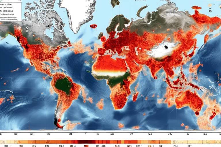
At the heart of modern border security is satellite surveillance technology. This technology plays a pivotal role by providing real-time imagery and data that help identify unauthorized crossings and potential threats. With the ability to cover large areas and capture detailed images, satellites serve as the first line of defense against illegal activities. They allow security forces to monitor borders continuously, ensuring that any suspicious activity is detected promptly. The integration of advanced imaging techniques and data analysis helps in creating a comprehensive security framework that is both proactive and reactive.
The collection and analysis of satellite data are essential for understanding border dynamics. By utilizing sophisticated algorithms, security agencies can analyze patterns of movement, which aids in the detection of illegal activities such as smuggling or human trafficking. This data-driven approach enhances response strategies, allowing for timely interventions. For instance, if a satellite detects a sudden influx of vehicles at a border crossing, security forces can be alerted immediately, enabling them to investigate the situation before it escalates.
One of the most effective methods employed in satellite surveillance is remote sensing techniques. These techniques utilize satellite imagery to monitor environmental changes and human activities near borders. By analyzing this data, authorities can identify potential security threats and allocate resources accordingly. Remote sensing not only helps in tracking illegal activities but also provides insights into natural disasters that may affect border security.
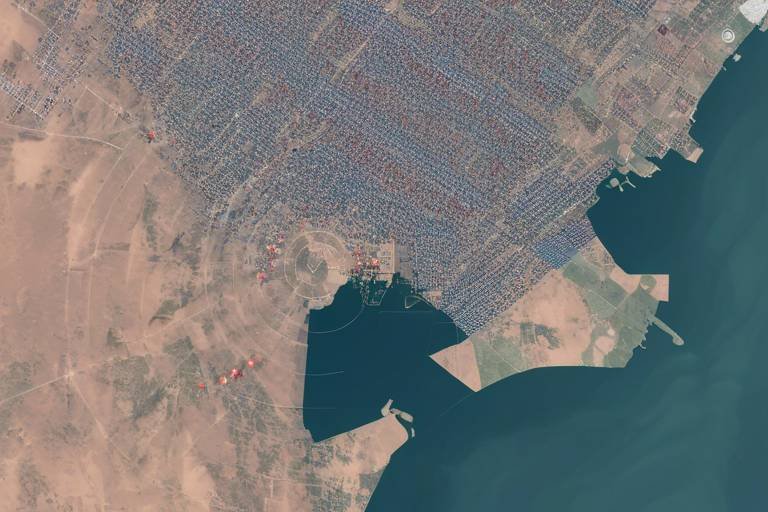
Optical imaging captures high-resolution images that assist security agencies in detecting unusual movements and activities along national borders. This technology can differentiate between various objects, making it easier to identify vehicles, individuals, and even cargo. The clarity and detail provided by optical imaging are crucial for making informed decisions in real-time.
On the other hand, radar technology enables continuous monitoring in various weather conditions, ensuring comprehensive surveillance of border areas. Unlike optical imaging, radar can penetrate clouds and operate in darkness, making it an invaluable asset for nighttime surveillance or during adverse weather. This capability ensures that no suspicious activity goes unnoticed, regardless of environmental challenges.
Integrating satellite data with ground-based systems allows for a more coordinated approach to border security. This integration enhances situational awareness and response capabilities, creating a synergy between aerial surveillance and on-the-ground intelligence. By combining satellite imagery with data from drones and ground patrols, security agencies can create a multi-layered defense strategy that maximizes resource efficiency.
In an increasingly interconnected world, international cooperation in satellite technology sharing enhances collective border security efforts. Countries can collaborate and share intelligence on potential threats, creating a united front against security challenges. This cooperation is essential, especially in regions where borders are porous and illegal activities are rampant.
Joint surveillance initiatives leverage satellite capabilities among allied nations to monitor shared borders. By pooling resources and sharing data, countries can improve overall security and response mechanisms. This collaborative approach not only strengthens security but also fosters diplomatic relations among nations.
Furthermore, data sharing agreements facilitate the exchange of satellite information, allowing countries to act swiftly against cross-border threats. These agreements enhance regional stability by ensuring that nations are informed about potential risks, enabling them to respond effectively to any emerging threats.
Despite their advantages, satellite systems face challenges such as high costs, technical limitations, and the need for skilled personnel to operate and analyze the data effectively. Understanding these challenges is crucial for optimizing the use of satellite technology in border security.
The high cost of satellite technology can be a barrier for some nations, limiting their ability to deploy advanced surveillance systems for border security. Investing in satellite infrastructure requires substantial financial resources, which may not be feasible for all countries. This disparity can lead to unequal security measures across regions.
Additionally, technical limitations, such as data resolution and coverage, can impact the effectiveness of satellite surveillance. In some cases, the quality of data may not be sufficient to make accurate assessments. As a result, complementary ground-based systems are often necessary to ensure comprehensive security.
- How do satellites help in border security? Satellites provide real-time imagery and data that help identify unauthorized crossings and potential threats, enhancing national security.
- What technologies are used in satellite surveillance? Technologies such as optical imaging and radar are commonly used to monitor borders effectively.
- Why is international cooperation important in satellite surveillance? International cooperation allows countries to share intelligence and resources, improving overall border security.
- What are the challenges faced by satellite technology? Challenges include high costs, technical limitations, and the need for skilled personnel to analyze data.
Satellite Surveillance Technology
When we think about border security, the first images that may come to mind are patrol officers and physical barriers. However, in today’s digital age, has emerged as a game-changer in how nations monitor and protect their borders. Imagine having a bird's-eye view of vast stretches of land, capable of detecting even the slightest movement. This is exactly what satellite technology offers, providing real-time imagery and data that are crucial for identifying unauthorized crossings and potential threats.
One of the most significant advantages of satellite surveillance is its ability to cover large areas with minimal human intervention. Traditional methods of border monitoring often rely on physical presence, which can be resource-intensive and limited in scope. In contrast, satellites orbiting the Earth can continuously scan vast regions, offering a comprehensive view that is impossible to achieve through ground-based methods alone. This capability allows security agencies to respond swiftly to any suspicious activities, ensuring that potential threats are addressed before they escalate.
Furthermore, is not just about watching; it's also about understanding. The data collected from these satellites can be analyzed to reveal patterns and trends that may indicate illegal activities, such as smuggling or unauthorized crossings. By leveraging advanced analytics, agencies can gain insights into border dynamics, enabling them to improve their response strategies significantly. For instance, if a particular area shows a spike in unauthorized crossings, authorities can allocate resources more effectively, deploying personnel to hotspots where they are needed most.
To illustrate the effectiveness of satellite surveillance, consider the following table that highlights key features of various satellite technologies:
| Technology | Features | Benefits |
|---|---|---|
| Optical Imaging | High-resolution images, color imagery | Detects unusual movements and activities |
| Radar Technology | Continuous monitoring, all-weather capability | Ensures comprehensive surveillance |
| Infrared Sensors | Heat detection, night vision | Identifies movement in low visibility conditions |
As we delve deeper into the world of satellite surveillance, it's essential to recognize that this technology is not a standalone solution. It works best when integrated with ground-based systems, creating a cohesive security network that enhances situational awareness. By combining satellite data with information from ground sensors and patrols, agencies can build a more complete picture of border activities, allowing for timely interventions when necessary.
In conclusion, is revolutionizing the way nations secure their borders. By providing real-time data and comprehensive coverage, it empowers security agencies to detect threats more efficiently and allocate resources effectively. As this technology continues to evolve, we can only anticipate even greater advancements in how we protect our national borders.
Data Collection and Analysis
The collection and analysis of satellite data are critical components in understanding the complexities of border dynamics. Imagine trying to navigate a bustling city without a map; it would be nearly impossible to know where to go or what obstacles lie ahead. In the same way, satellite technology provides a comprehensive map of border areas, allowing security agencies to visualize potential threats and unauthorized activities effectively. By harnessing the power of real-time data, nations can make informed decisions that bolster their defense strategies and enhance overall security.
Through advanced algorithms and data processing techniques, satellite systems can analyze vast amounts of information, identifying patterns that might indicate illegal crossings or suspicious activities. For instance, if a sudden surge of movement is detected in a remote area, security forces can be alerted to investigate further. This proactive approach not only helps in preventing illegal activities but also aids in resource allocation, ensuring that personnel and equipment are deployed where they are needed most.
To illustrate the significance of data collection, consider the following table that summarizes the key types of data collected through satellite surveillance:
| Data Type | Description | Use Case |
|---|---|---|
| Imagery Data | Visual images captured by satellites | Identifying unauthorized border crossings |
| Infrared Data | Heat signatures detected from space | Monitoring human activity at night |
| Radar Data | Data collected using radar technology | Tracking movements in inclement weather |
Moreover, the integration of satellite data with machine learning algorithms allows for predictive analysis. By examining historical data trends, algorithms can forecast potential security breaches before they occur. This capability transforms satellite surveillance from a reactive measure into a proactive shield, enhancing border security significantly. Just as a seasoned chess player anticipates their opponent's moves, security agencies can now anticipate threats and allocate resources efficiently.
However, the effectiveness of data collection hinges on the quality of the satellite systems in place. High-resolution imagery and reliable data transmission are essential to ensure that security agencies receive accurate and timely information. Without these critical elements, the risk of missing out on vital intelligence increases, potentially compromising national security.
In conclusion, the role of data collection and analysis in satellite technology cannot be overstated. It is not merely about gathering information; it is about transforming that data into actionable insights that can protect borders and enhance national security. With the right tools and technologies, nations can stay one step ahead of potential threats, ensuring the safety and security of their citizens.
- How do satellites detect unauthorized border crossings?
Satellites utilize high-resolution imagery and radar data to monitor border areas, identifying unusual movements that may indicate illegal crossings. - What types of data do satellites collect for border security?
Satellites collect various data types, including imagery data, infrared data, and radar data, all of which contribute to comprehensive border surveillance. - Can satellite data predict future security threats?
Yes, by analyzing historical data trends using machine learning algorithms, satellite systems can forecast potential security breaches before they occur.
Remote Sensing Techniques
Remote sensing techniques are at the forefront of modern border security, acting like a watchful eye in the sky. These methods utilize satellite imagery to monitor both environmental changes and human activities near national borders. Imagine having a bird's-eye view of vast stretches of land, where every movement can be tracked and analyzed. This capability allows authorities to intervene swiftly when suspicious activities are detected, ensuring that borders remain secure.
One of the most exciting aspects of remote sensing is its ability to provide data that is not only timely but also rich in detail. For instance, satellite images can reveal patterns of movement that might go unnoticed by ground patrols. This is particularly useful in remote areas where human surveillance is limited. By employing advanced algorithms, security agencies can analyze these images to pinpoint unusual behaviors, such as unauthorized crossings or smuggling activities.
Moreover, the integration of remote sensing with other technologies enhances its effectiveness. For example, when satellite data is combined with ground-based sensors, it creates a comprehensive surveillance network. This synergy allows for a more nuanced understanding of border dynamics. As a result, security forces can allocate resources more efficiently, deploying personnel to hotspots identified through satellite imagery.
To illustrate the impact of remote sensing techniques, consider the following table that summarizes some key applications:
| Technique | Description | Application |
|---|---|---|
| Optical Imaging | Captures high-resolution images of the Earth's surface. | Detects unusual movements and activities. |
| Radar Technology | Uses radio waves to detect objects and monitor conditions. | Provides continuous surveillance in all weather. |
| Infrared Sensing | Detects heat signatures from moving objects. | Identifies unauthorized vehicles or individuals at night. |
The versatility of remote sensing techniques not only aids in immediate threat detection but also contributes to long-term strategic planning. By analyzing historical data, security agencies can identify trends over time, allowing them to anticipate potential threats before they materialize. This proactive approach is crucial in a world where border security is constantly challenged by evolving tactics of illegal activities.
In conclusion, remote sensing techniques are indispensable in the realm of national security. They provide a comprehensive view of border areas, enabling authorities to respond to threats with agility and precision. As technology continues to advance, the potential for these techniques to enhance border security will only grow, making them a vital component of modern defense strategies.
- What is remote sensing? Remote sensing refers to the acquisition of information about an object or phenomenon without making physical contact, typically using satellite or aerial imagery.
- How does remote sensing improve border security? It enhances border security by providing real-time data and imagery that help detect unauthorized movements and potential threats.
- What are the limitations of remote sensing? Limitations include high costs, technical constraints like data resolution, and the need for skilled personnel to analyze the data effectively.
Optical Imaging
Optical imaging is a game-changer in the realm of border security, providing high-resolution images that are crucial for monitoring activities along national borders. Imagine being able to see every detail from space; that’s the power of optical imaging. It utilizes visible light and infrared sensors to capture images that can reveal unauthorized crossings, suspicious gatherings, or even changes in the environment that may indicate illegal activities. This technology not only enhances situational awareness but also allows security agencies to make informed decisions quickly.
One of the most significant advantages of optical imaging is its ability to produce crystal-clear visuals. This clarity enables analysts to differentiate between various objects and movements, making it easier to identify potential threats. For instance, a sudden increase in vehicle traffic at a remote border crossing can be flagged as unusual, prompting further investigation. In addition, the data collected can be archived and analyzed over time, providing valuable insights into patterns and trends that may not be immediately apparent.
However, it's essential to understand that optical imaging is not without its limitations. Factors such as weather conditions and daylight availability can significantly affect the quality of the images captured. For example, cloudy days or nighttime conditions can obscure visibility, making it challenging to gather reliable data. To overcome these challenges, many agencies are integrating optical imaging with other technologies, such as radar, to ensure comprehensive monitoring regardless of environmental conditions.
Furthermore, the effectiveness of optical imaging can be enhanced through the use of advanced algorithms and artificial intelligence (AI). These technologies can help automate the analysis of vast amounts of data, allowing for quicker identification of anomalies. By employing machine learning techniques, security agencies can train systems to recognize specific patterns associated with illegal activities, thereby improving their response times and operational efficiency.
In conclusion, optical imaging serves as a critical tool in the arsenal of border security technology. Its ability to provide detailed and actionable intelligence makes it indispensable for monitoring and protecting national borders. As technology continues to evolve, the integration of optical imaging with other surveillance methods will pave the way for even more robust security measures, ensuring that nations can respond effectively to emerging threats.
- What is optical imaging? Optical imaging is a technology that captures high-resolution images using visible light and infrared sensors, enabling detailed monitoring of areas, including national borders.
- How does optical imaging enhance border security? It provides clear visuals that help identify unauthorized crossings and suspicious activities, allowing security agencies to respond quickly to potential threats.
- Are there limitations to optical imaging? Yes, weather conditions and daylight can affect image quality, which is why it is often combined with other technologies like radar for comprehensive monitoring.
- Can AI improve the effectiveness of optical imaging? Absolutely! AI can automate data analysis and help identify patterns associated with illegal activities, improving response times for security agencies.
Radar Technology
Radar technology has emerged as a game-changer in the realm of border security, providing an unparalleled ability to monitor vast areas with precision and reliability. Unlike traditional surveillance methods, radar systems can operate effectively under a variety of environmental conditions, including fog, rain, and even darkness. This capability ensures that national borders are continuously monitored, allowing security agencies to detect potential threats in real-time.
Imagine a watchful eye that never blinks; that's what radar technology offers. It utilizes radio waves to identify objects, measure their distance, and track their movements. This technology is particularly useful for detecting unauthorized crossings, as it can pick up on the faintest signals that might otherwise go unnoticed. The integration of radar systems with satellite technology creates a comprehensive surveillance network that enhances situational awareness.
To illustrate the effectiveness of radar technology in border security, consider the following key advantages:
- All-Weather Capability: Radar systems can function in adverse weather conditions, ensuring that monitoring efforts are not hindered by rain, snow, or fog.
- Real-Time Data: The ability to provide instant feedback allows security forces to react swiftly to any detected anomalies.
- Wide Coverage: Radar can scan large areas, making it ideal for monitoring remote and difficult-to-access border regions.
Furthermore, radar technology can be categorized into two primary types: ground-based radar and airborne radar. Ground-based radar systems are strategically placed along borders to provide a constant watch, while airborne radar systems can cover even larger areas from the sky, providing a bird's-eye view of the terrain below. These systems can be deployed on drones or aircraft, further enhancing their versatility.
In conclusion, radar technology represents a crucial component of modern border security strategies. Its ability to deliver reliable, real-time data in any weather condition significantly boosts the effectiveness of national defense efforts. As countries continue to invest in advanced radar systems, we can expect enhanced security measures that not only protect borders but also foster a sense of safety within communities.
- What is radar technology? Radar technology uses radio waves to detect and track objects, providing valuable data for surveillance and monitoring.
- How does radar technology benefit border security? It offers all-weather monitoring capabilities, real-time data, and wide coverage to detect unauthorized crossings and potential threats.
- Can radar technology operate at night? Yes, one of the significant advantages of radar technology is its ability to function effectively in low-light conditions.
- What are the different types of radar systems used in border security? The primary types are ground-based radar and airborne radar, each serving specific monitoring needs.
Integration with Ground Systems
When we talk about securing national borders, it's crucial to understand that satellite technology doesn't operate in isolation. Instead, it works hand-in-hand with ground systems to create a comprehensive security framework. Imagine trying to solve a puzzle; each piece is necessary to see the complete picture. Similarly, integrating satellite data with ground-based systems enhances situational awareness and response capabilities, making it easier for security agencies to act swiftly and effectively.
The integration process involves a seamless flow of information between satellites and ground systems, allowing for real-time data exchange. This means that while satellites are capturing high-resolution images of border areas, ground units are receiving updates on potential threats or unauthorized crossings. This synergy not only improves response times but also enables a more coordinated approach to border management. For example, if a satellite detects unusual movement near a border, ground forces can be immediately dispatched to investigate, preventing potential breaches before they escalate.
Moreover, the integration of satellite data with ground systems can be illustrated through various technological advancements. For instance, the use of Geographic Information Systems (GIS) allows agencies to map and analyze data effectively. By layering satellite imagery with ground-based information, such as terrain features and human activity patterns, security personnel can better understand the dynamics at play. This holistic view facilitates strategic decision-making and resource allocation, ensuring that security measures are both proactive and reactive.
In addition to GIS, other technologies like drone surveillance and real-time communication systems further strengthen the integration process. Drones can provide on-the-ground visuals that complement the satellite data, while communication systems ensure that all units are on the same page, sharing critical information as it happens. This interconnectedness is vital for addressing the multifaceted challenges of border security.
However, it's important to note that while integration offers significant advantages, it also requires substantial investment in technology and training. Security agencies must ensure that personnel are well-equipped to interpret satellite data and respond appropriately. This means ongoing education and the development of technical skills are just as important as the technology itself.
In conclusion, the integration of satellite technology with ground systems is a game-changer in national border security. It creates a robust framework that enhances situational awareness, improves response capabilities, and ultimately ensures that borders are monitored and protected effectively. As we move forward, embracing this integration will be essential for adapting to evolving threats and maintaining national security.
- What is the primary benefit of integrating satellite technology with ground systems?
The primary benefit is enhanced situational awareness, which allows for quicker and more coordinated responses to potential threats. - How does satellite data contribute to border security?
Satellite data provides real-time imagery and information that helps identify unauthorized crossings and monitor border activities effectively. - What technologies are used in the integration process?
Technologies such as Geographic Information Systems (GIS), drone surveillance, and real-time communication systems are commonly used in the integration process. - Are there challenges associated with this integration?
Yes, challenges include the need for substantial investment in technology, ongoing training for personnel, and addressing technical limitations.
International Cooperation
In today's interconnected world, the role of in enhancing border security through satellite technology cannot be overstated. Countries are increasingly recognizing that threats do not respect borders; therefore, a unified approach is essential. By sharing satellite data and resources, nations can bolster their defenses and create a more secure environment. Imagine a neighborhood where everyone keeps an eye out for each other's homes; that’s the essence of international collaboration in security.
One of the most effective ways to achieve this cooperation is through joint surveillance initiatives. These initiatives allow allied nations to pool their satellite capabilities, effectively monitoring shared borders. For instance, countries in a regional alliance can coordinate their satellite surveillance efforts to cover larger areas more comprehensively. This collaboration can lead to quicker detection of illegal activities, such as smuggling or human trafficking, and enable faster response times.
Furthermore, data sharing agreements play a crucial role in this cooperative framework. Such agreements facilitate the exchange of critical satellite information among nations, allowing them to act swiftly against potential threats. Imagine a fire alarm system where all houses are connected; when one detects smoke, all others are alerted. Similarly, when countries share satellite data, they enhance their collective ability to respond to cross-border threats. This not only improves national security but also fosters regional stability, as nations work together to address common challenges.
| Benefits of International Cooperation | Examples |
|---|---|
| Enhanced Threat Detection | Joint satellite monitoring of high-risk areas |
| Resource Optimization | Pooling satellite resources for cost-effective solutions |
| Improved Response Times | Shared intelligence leading to quicker action |
| Strengthened Diplomatic Relations | Collaborative efforts foster trust among nations |
However, while the advantages are clear, international cooperation in satellite surveillance is not without challenges. Issues such as differing national policies, varying levels of technological advancement, and concerns about data privacy can hinder effective collaboration. Nevertheless, the potential benefits far outweigh these obstacles. By working together, nations can create a robust defense network that not only protects their borders but also promotes peace and stability in the region.
- Why is international cooperation essential for border security?
International cooperation enhances threat detection and response capabilities, allowing nations to act swiftly against common threats. - What are joint surveillance initiatives?
These are collaborative efforts among allied nations to monitor shared borders using satellite technology. - How do data sharing agreements work?
Data sharing agreements facilitate the exchange of satellite information, enabling countries to enhance their collective security efforts. - What challenges does international cooperation face?
Challenges include differing national policies, varying technological capabilities, and concerns over data privacy.
Joint Surveillance Initiatives
Joint surveillance initiatives represent a groundbreaking approach in the realm of national security, where allied nations come together to leverage their satellite capabilities for enhanced border monitoring. Imagine a vast network of eyes in the sky, each contributing to a collective effort to secure borders that are not just national, but shared among friends and allies. This collaboration is vital, especially in an era where threats can easily cross borders, making it essential for countries to work together in real-time.
These initiatives often involve the sharing of satellite imagery and data, which allows participating nations to gain a comprehensive understanding of border dynamics. For instance, when one country detects unusual activity along its border, it can quickly share that information with neighboring countries, enabling a coordinated response. This is akin to a neighborhood watch program, where everyone looks out for one another, ensuring that any suspicious activity is addressed promptly.
Furthermore, joint surveillance initiatives can lead to the establishment of common operational protocols. This means that countries can standardize their responses to various threats, making it easier to act swiftly and effectively. By working together, countries can pool their resources and technology, maximizing their surveillance capabilities while minimizing costs. For example, if two countries share a satellite system, they can monitor their borders more efficiently than if they operated in isolation.
However, the success of these initiatives depends heavily on trust and communication between nations. Regular meetings and updates can help maintain transparency and ensure that all parties are on the same page. The commitment to joint surveillance can significantly improve regional stability, as countries are more likely to work together to address potential threats rather than acting unilaterally.
In summary, joint surveillance initiatives are a powerful tool in the arsenal of modern border security. By fostering collaboration and sharing valuable data, countries can enhance their situational awareness and response capabilities, ultimately leading to a safer environment for all. As we move forward, it's crucial for nations to continue investing in these partnerships, ensuring that they are prepared to tackle the evolving landscape of security challenges together.
- What are joint surveillance initiatives?
Joint surveillance initiatives involve multiple countries collaborating to share satellite data and resources for enhanced border security. - How do these initiatives improve border security?
They enable real-time data sharing, allowing countries to respond quickly to potential threats and monitor shared borders more effectively. - What challenges do joint surveillance initiatives face?
Challenges include trust between nations, the need for standardized protocols, and the sharing of sensitive information. - Can joint surveillance initiatives reduce costs?
Yes, by pooling resources and technology, countries can achieve better surveillance capabilities at a lower cost than if they operated independently.
Data Sharing Agreements
are crucial frameworks that enable countries to collaborate effectively in the realm of border security. These agreements facilitate the exchange of vital satellite information, which can significantly enhance a nation's ability to respond to cross-border threats. Imagine a scenario where two neighboring countries are constantly on alert for illegal activities along their shared border. By entering into a data sharing agreement, they can pool their resources and intelligence, creating a more robust defense against potential incursions.
These agreements typically outline the terms of information exchange, including what data will be shared, how it will be used, and the protocols for maintaining security and confidentiality. For instance, a country might share satellite imagery that reveals unusual movements near the border, while the neighboring country could provide ground-level intelligence that complements the satellite data. This synergy not only improves situational awareness but also fosters trust and cooperation between nations.
In practical terms, data sharing agreements can take various forms, including bilateral or multilateral treaties. These can involve military agencies, intelligence organizations, or even civilian governmental bodies, depending on the nature of the threat and the countries involved. For example, NATO countries have established frameworks for sharing intelligence, which include satellite data, to enhance collective security. The benefits of such arrangements are manifold:
- Enhanced Responsiveness: Countries can act swiftly against emerging threats by having real-time access to shared data.
- Improved Resource Allocation: By understanding the full scope of border activities, nations can allocate their resources more effectively, focusing on high-risk areas.
- Increased Regional Stability: Collaborative efforts can deter illegal activities, leading to a more stable border environment.
However, the implementation of these agreements is not without challenges. Issues such as data privacy, political considerations, and the potential for misuse of shared information can complicate matters. Countries must navigate these challenges carefully to ensure that the agreements are beneficial and that trust is maintained. Ultimately, effective data sharing agreements can serve as a powerful tool in the arsenal of national security, turning isolated efforts into a cohesive strategy to secure borders.
- What are data sharing agreements? These are formal agreements between countries to share information, particularly related to security and surveillance, to enhance border protection.
- How do data sharing agreements improve national security? They allow for the exchange of critical information, enabling countries to respond more effectively to threats and monitor border activities in real time.
- Are there challenges associated with data sharing agreements? Yes, challenges include data privacy concerns, political issues, and the potential misuse of shared information.
Challenges and Limitations
While satellite technology is a game-changer in enhancing national security, it is not without its . These hurdles can significantly impact the effectiveness of satellite surveillance systems and their ability to secure national borders. One of the most pressing issues is the high cost of implementation. Deploying advanced satellite systems requires substantial financial investment, which can be a barrier for many nations, particularly those with limited budgets. The cost includes not only the satellites themselves but also the infrastructure needed for data processing and analysis. For example, a single satellite launch can cost millions of dollars, and maintaining these systems further adds to the financial burden.
Another significant challenge lies in the technical limitations of satellite technology. Despite advancements, many satellites still face issues related to data resolution and coverage. For instance, while some satellites can capture high-resolution images, they may not provide continuous coverage of vast border areas. This limitation necessitates the use of complementary ground-based systems to fill the gaps in surveillance. In some cases, the data collected might not be detailed enough to detect subtle movements or activities that could indicate a potential threat. Thus, relying solely on satellite technology can lead to critical oversights.
Additionally, there is a pressing need for skilled personnel to operate and analyze satellite data effectively. The complexity of satellite systems requires trained professionals who can interpret the data accurately and make informed decisions. Unfortunately, many countries struggle to find individuals with the necessary expertise, which can hinder the overall effectiveness of border security measures. The lack of human resources can lead to delays in response times and an inability to act swiftly against potential threats.
To summarize, while satellite technology offers remarkable benefits for national security, the challenges of high implementation costs, technical limitations, and the need for skilled personnel pose significant hurdles. Addressing these challenges is crucial for countries looking to enhance their border security through satellite surveillance.
- What are the primary challenges of satellite technology in border security?
The main challenges include high implementation costs, technical limitations regarding data resolution and coverage, and the need for skilled personnel for data analysis. - How do technical limitations impact satellite surveillance?
Technical limitations can result in insufficient data quality and coverage, necessitating the use of additional ground-based systems to ensure comprehensive monitoring. - Why is skilled personnel important in satellite data analysis?
Skilled personnel are essential for accurately interpreting satellite data and making timely decisions, which is crucial for effective border security responses.
Cost of Implementation
The implementation of satellite technology for border security is a significant financial investment that many nations must consider carefully. The costs associated with deploying and maintaining satellite systems can be daunting, often reaching into the billions of dollars. This high price tag can create a substantial barrier, particularly for developing countries that may struggle to allocate sufficient funds for such advanced technology. To put this into perspective, let's break down some of the key cost components:
| Cost Component | Estimated Cost |
|---|---|
| Satellite Launch | $100 million - $500 million |
| Ground Control Stations | $10 million - $50 million |
| Data Processing and Analysis Systems | $5 million - $20 million |
| Operational Maintenance | $2 million - $10 million annually |
As illustrated in the table above, the initial costs for launching satellites and establishing ground control stations can be astronomical. Moreover, the ongoing operational and maintenance costs can add to the financial burden. For many nations, especially those with limited budgets, these expenses can mean that they have to prioritize their spending, often at the expense of other critical areas like education or healthcare.
Additionally, the technical expertise required to operate and analyze the data from these satellites is another hidden cost. Nations need to invest in training personnel who can effectively manage these sophisticated systems. This includes not only the technical know-how to operate satellites but also the analytical skills to interpret the vast amounts of data they generate. Without skilled personnel, even the most advanced technology can fall short of its potential, leading to wasted resources and missed opportunities for enhancing border security.
In conclusion, while the benefits of satellite technology for securing national borders are undeniable, the poses a significant challenge. Nations must weigh the potential advantages against the financial implications, often leading to difficult decisions about resource allocation. As technology continues to evolve, it is crucial for countries to explore innovative funding solutions and international partnerships that can help mitigate these costs, ensuring that they can effectively safeguard their borders without compromising other essential services.
- What are the main costs associated with satellite technology for border security?
The main costs include satellite launch, ground control stations, data processing systems, and ongoing operational maintenance.
- How can developing countries afford satellite technology?
Developing countries can explore international partnerships, funding from global organizations, and shared technology initiatives to reduce costs.
- What skills are necessary to operate satellite systems?
Personnel need technical skills for operation and analytical skills to interpret data effectively.
Technical Limitations
While satellite technology has revolutionized the way we monitor and secure national borders, it is not without its . These challenges can significantly impact the effectiveness of satellite surveillance systems, making it crucial for nations to understand and address them effectively. One of the primary concerns is data resolution. High-resolution images are essential for accurately identifying objects and movements, but not all satellites are equipped with the same level of detail. This limitation can lead to missed detections or misinterpretations of what is being observed, especially in crowded or complex environments.
Another major issue is coverage. Satellites operate in fixed orbits, which means that there are times when specific areas may not be under surveillance. For instance, if a satellite is passing overhead, it may only capture images of a location once every few hours or days, depending on its orbit. This sporadic monitoring can create gaps in security, allowing unauthorized crossings or illicit activities to go unnoticed.
Moreover, environmental factors such as weather conditions can severely affect satellite performance. Cloud cover, rain, and fog can obstruct the view of optical imaging systems, making it difficult to gather clear data. On the other hand, radar technology can penetrate through clouds, but it comes with its own set of limitations, such as reduced resolution and the potential for false positives. This duality of strengths and weaknesses means that a combination of technologies is often necessary for comprehensive border surveillance.
Lastly, the need for skilled personnel cannot be overlooked. The sophisticated nature of satellite systems requires trained experts who can operate the technology and analyze the data effectively. Without the right human resources, even the most advanced systems can fall short of their potential. Countries must invest not only in technology but also in the education and training of their workforce to ensure that they can fully leverage the capabilities of satellite surveillance.
In summary, while satellite surveillance offers significant advantages for national border security, understanding its technical limitations is crucial for optimizing its use. By addressing issues related to data resolution, coverage, environmental factors, and the need for skilled personnel, nations can enhance their security measures and ensure that they are prepared to respond to threats effectively.
- What are the main advantages of satellite surveillance for border security? Satellite surveillance provides real-time data, high-resolution imagery, and the ability to monitor remote areas that are difficult to access.
- How does weather affect satellite operations? Weather conditions like clouds and heavy rain can obstruct optical imaging, while radar systems may experience reduced resolution under certain conditions.
- What is the importance of skilled personnel in satellite operations? Skilled personnel are essential for operating the technology and analyzing the data, ensuring that the information gathered is used effectively for security purposes.
- Can satellite technology work alongside ground-based systems? Yes, integrating satellite data with ground-based systems can provide a more comprehensive approach to border security, enhancing situational awareness.
Frequently Asked Questions
- How do satellites improve border security?
Satellites enhance border security by providing real-time imagery and data that help identify unauthorized crossings and detect potential threats. This technology allows security agencies to monitor vast areas efficiently, ensuring that any unusual activities are promptly addressed.
- What types of satellite technology are used for surveillance?
There are various types of satellite technology used for surveillance, including optical imaging, which captures high-resolution images, and radar technology, which enables continuous monitoring regardless of weather conditions. Both play crucial roles in maintaining border security.
- What is remote sensing and how does it relate to border security?
Remote sensing involves using satellite imagery to monitor environmental changes and human activities near borders. This technique helps security agencies facilitate timely interventions and allocate resources effectively, making it a vital component of modern border security strategies.
- How does international cooperation enhance satellite surveillance?
International cooperation, such as joint surveillance initiatives and data sharing agreements, allows countries to collaborate and share intelligence on potential threats. This collective effort significantly improves overall security and response mechanisms at shared borders.
- What are some challenges associated with satellite technology in border security?
Despite its advantages, satellite technology faces challenges, including high implementation costs, technical limitations like data resolution and coverage, and the need for skilled personnel to operate and analyze the data effectively. These factors can hinder the deployment of advanced surveillance systems.
- Are there alternatives to satellite surveillance for border security?
Yes, while satellite surveillance is effective, it is often complemented by ground-based systems such as cameras, drones, and patrols. These alternatives can provide more detailed information and immediate responses to security threats.