How Satellites Aid in Monitoring Political Instability
In today's fast-paced world, the role of satellites in monitoring political instability cannot be overstated. These technological marvels orbiting our planet serve as the eyes in the sky, providing critical insights into regions experiencing turmoil. Imagine being able to see the movements of troops, the gathering of crowds, or even the aftermath of natural disasters—all from space! This capability not only enhances our understanding of conflict zones but also plays a vital role in global security. By collecting and analyzing data, satellites help governments, NGOs, and international organizations make informed decisions that can save lives and promote peace.
As we delve deeper into the fascinating intersection of satellite technology and political instability, you'll discover how these tools have transformed our ability to respond to crises. With advancements in satellite capabilities, we can now monitor events in real-time, offering a level of situational awareness that was previously unimaginable. This article will explore the various ways satellites contribute to tracking political unrest, the methods used to analyze the data they collect, and the importance of international collaboration in enhancing these monitoring efforts.
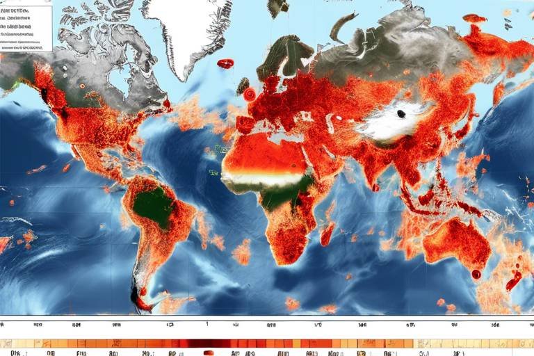
Satellite technology has truly revolutionized the landscape of data collection and analysis. Gone are the days when information about political events was primarily gathered through on-the-ground reports, which could be biased or incomplete. Today, satellites offer a bird's-eye view of the world, enabling us to monitor political events as they unfold. With high-resolution imaging capabilities, satellites can capture detailed images of conflict zones, infrastructure, and even crowd movements. This level of detail is crucial for understanding the dynamics of political instability.
Moreover, advancements in satellite technology, such as synthetic aperture radar (SAR) and multispectral imaging, allow for the collection of data under various conditions, including night-time and adverse weather. This means that even when traditional methods fail, satellites continue to gather vital information. The integration of artificial intelligence (AI) and machine learning into satellite data analysis further enhances our ability to detect patterns and anomalies, providing timely alerts about potential unrest. As we continue to harness these technologies, the potential for more effective monitoring and intervention in political crises grows exponentially.
At the heart of satellite monitoring lies the vast amounts of data collected from various sources. Satellites gather everything from thermal images to visual spectrums, which can then be analyzed for patterns of instability. But how exactly do we process this data? The methods employed range from simple visual analysis to complex algorithms that identify trends and correlations. By using sophisticated software, analysts can sift through terabytes of data to pinpoint areas of concern before they escalate into full-blown crises.
Remote sensing techniques play a crucial role in observing geographical and human activities that may signal political unrest. For instance, changes in land use, such as the sudden construction of military bases or the clearing of land for protests, can be detected through satellite imagery. These observations help analysts understand the underlying factors contributing to instability. Additionally, remote sensing can track the movement of refugees or displaced populations, providing invaluable data for humanitarian organizations responding to crises.
Visual data interpretation is another essential component of analyzing satellite images. By employing visual analytics, experts can identify signs of political instability, such as the presence of large gatherings or unusual military activity. This technique not only aids in immediate response efforts but also helps build a comprehensive understanding of the situation over time. The ability to visualize data effectively can often reveal trends that raw numbers alone cannot convey, making it an indispensable tool in the realm of political monitoring.
Geospatial analysis takes the understanding of political events a step further by examining the spatial relationships involved. By mapping conflict areas and overlaying various data sets, analysts can predict potential unrest and assess the impact of geographic factors on political stability. For example, if a satellite detects a surge in troop movements near a border, geospatial analysis can help determine the likelihood of conflict based on historical patterns and geographical features. This predictive capability is invaluable for governments and organizations aiming to mitigate risks and respond proactively to emerging threats.
To illustrate the practical applications of satellite monitoring, let's examine some case studies where satellite data has played a pivotal role. For instance, during the Arab Spring, satellites provided real-time imagery of protests, enabling governments and NGOs to assess the situation accurately. Similarly, in regions like Syria, satellite data has been instrumental in monitoring the effects of conflict on infrastructure and civilian populations. These examples highlight not only the effectiveness of satellite monitoring but also its potential to inform international responses to political instability.
International collaboration is key to enhancing the effectiveness of satellite monitoring. By pooling resources and expertise, nations can strengthen their monitoring capabilities and improve responses to political crises. Collaborative efforts, such as joint satellite missions, enable countries to share data and insights, fostering a more comprehensive understanding of global political dynamics.
Joint satellite missions are a prime example of how collaboration can enhance monitoring capabilities. These missions allow multiple countries to share the costs and benefits associated with satellite technology. For instance, the European Space Agency and NASA have collaborated on various projects that enable more comprehensive data collection and analysis. By working together, nations can maximize the impact of their satellite resources, leading to more effective monitoring of political instability.
Data sharing agreements among countries further enhance situational awareness. By establishing protocols for sharing satellite data, nations can respond more swiftly to emerging political threats. These agreements facilitate timely communication and collaboration, ensuring that critical information reaches decision-makers when it matters most. In an age where political instability can escalate rapidly, having access to real-time data is crucial for effective crisis management.
- How do satellites monitor political instability? Satellites collect data through imaging technology, allowing for real-time observation of conflict zones and political events.
- What types of data do satellites collect? Satellites gather various types of data, including thermal images, visual spectrums, and remote sensing information.
- Why is international collaboration important in satellite monitoring? Collaborative efforts enhance resource sharing, improve data accuracy, and strengthen responses to political crises.
- Can satellite data predict political unrest? Yes, through advanced analysis techniques, satellite data can identify patterns and anomalies that may indicate potential unrest.
The Role of Satellite Technology
Satellite technology has truly transformed the landscape of data collection, particularly in the realm of monitoring political instability. Imagine a bird's-eye view of the world, where every movement, every change in the environment can be observed and analyzed in real-time. This capability is no longer just a dream; it is a reality made possible by advancements in satellite technology. With high-resolution imaging and sophisticated sensors, satellites can capture detailed information about conflict zones, humanitarian crises, and even the subtle shifts in political climates.
One of the most significant advantages of satellite technology is its ability to operate independently of ground conditions. While traditional methods of gathering intelligence might rely on human sources or local reports, satellites can provide an unfiltered perspective, unaffected by biases or misinformation. This is crucial in areas where access is limited or where the situation on the ground is too dangerous for human observers. For example, during times of unrest, satellites can monitor troop movements, the destruction of infrastructure, or even the displacement of populations, offering invaluable insights that can guide international responses.
Moreover, the integration of machine learning and artificial intelligence into satellite technology has further enhanced its capabilities. These technologies enable analysts to sift through vast amounts of data and identify patterns that may indicate rising tensions or impending conflicts. By employing algorithms that can detect anomalies in satellite imagery, experts can predict where unrest is likely to occur, allowing governments and organizations to take proactive measures.
Another fascinating aspect of satellite technology is its ability to provide real-time updates. This immediacy is crucial in political situations where every second counts. For instance, during a coup or a significant political protest, timely information can mean the difference between effective intervention and catastrophic consequences. Satellites can relay critical data to decision-makers, ensuring that they are equipped with the most current information available.
In summary, the role of satellite technology in monitoring political instability cannot be overstated. It acts as a powerful tool for gathering intelligence, analyzing data, and providing insights that can help prevent conflicts and enhance global security. As we continue to refine these technologies and expand their applications, we can expect even more profound impacts on how we understand and respond to the complexities of political instability around the world.
Data Collection and Analysis
In today's fast-paced world, the ability to monitor political instability is more crucial than ever. Satellites serve as our eyes in the sky, collecting vast amounts of data that can be analyzed for patterns of unrest. But how exactly do these floating marvels gather and process information? It all starts with sophisticated technology that captures images and signals from the Earth's surface, allowing us to observe changes in real-time. This data is then meticulously analyzed to identify trends that may indicate potential conflicts or instability.
One of the primary methods of data collection involves remote sensing, which utilizes satellite sensors to capture information about the Earth's surface without direct contact. These sensors can detect various wavelengths of light, enabling them to observe everything from vegetation health to urban expansion. For instance, if a region experiences a sudden decrease in vegetation, it could signal a shift in land use, possibly due to civil unrest or military activity. By analyzing these changes, researchers can develop a clearer picture of the political landscape.
Moreover, the data collected is not just raw information; it's transformed into actionable insights through advanced data analysis techniques. Analysts employ algorithms and machine learning models to sift through terabytes of satellite imagery. They look for specific indicators of instability, such as:
- Changes in population density
- Destruction of infrastructure
- Movement of military assets
These indicators help experts predict potential hotspots of conflict before they escalate, allowing governments and organizations to respond proactively rather than reactively.
To illustrate the effectiveness of satellite data analysis, let's consider a simplified example: Imagine a nation experiencing protests. Satellite images can capture the size and location of gatherings, while changes in urban areas can reveal the impact of civil unrest on infrastructure. By correlating this visual data with social media activity and other intelligence sources, analysts can create a comprehensive overview of the situation, leading to informed decision-making.
In summary, the combination of data collection and analysis through satellite technology provides a powerful tool for monitoring political instability. As technology advances, the capabilities of satellites will only improve, allowing for even more precise and timely insights into global events. But this is just one piece of the puzzle; the collaboration between nations and organizations is equally vital in ensuring that this data is used effectively to foster peace and stability around the world.
Remote Sensing Techniques
Remote sensing techniques have become a pivotal tool in the realm of monitoring political instability. Imagine having the ability to observe vast areas of land from space, collecting data that reveals not just the physical characteristics of a region, but also the socio-political dynamics at play. This is exactly what remote sensing offers. By utilizing various types of sensors mounted on satellites, analysts can gather critical information about geographical features, human activities, and even environmental changes that may signal unrest.
One of the most fascinating aspects of remote sensing is its ability to capture data across different wavelengths of light. For instance, optical sensors can provide detailed images of land use and urban development, while radar sensors can penetrate cloud cover and provide insights even in adverse weather conditions. This versatility allows for a comprehensive understanding of areas that may be experiencing political turmoil. By analyzing these images, experts can identify patterns indicative of instability, such as the sudden increase in troop movements or the establishment of makeshift camps.
Moreover, remote sensing data can be integrated with other information sources, such as social media feeds and ground reports, to create a more nuanced picture of a region's political climate. This data fusion enhances the accuracy of predictions regarding potential conflicts. For example, if satellite imagery shows a spike in agricultural land being converted to military installations, combined with rising tensions reported on social media, analysts can sound the alarm on an impending crisis.
To illustrate the significance of remote sensing in political monitoring, consider the following key techniques:
- Multispectral Imaging: This technique captures data across multiple wavelengths, allowing for the differentiation of various land cover types and human activities.
- Thermal Imaging: Useful for detecting heat emitted from buildings or vehicles, this method can indicate military mobilizations or refugee movements.
- LiDAR (Light Detection and Ranging): This technique provides precise topographical information, which can be crucial for understanding geographical factors that contribute to instability.
In conclusion, remote sensing techniques not only enhance our understanding of geographical and human activities but also play a critical role in predicting and monitoring political instability. By leveraging these advanced technologies, we can gain valuable insights that help inform decision-makers and potentially avert crises before they escalate.
Visual Data Interpretation
Visual data interpretation is a cornerstone of understanding the complex tapestry of political instability. Imagine trying to decipher a foreign language without knowing the alphabet; that’s how challenging it can be to grasp the nuances of political events without the right visual tools. Satellite imagery provides a unique lens through which we can observe and analyze the world, revealing patterns that might otherwise go unnoticed. This process is not just about looking at pretty pictures from space; it’s about extracting meaningful insights that can inform decision-making and policy formulation.
The significance of visual analytics in identifying signs of political instability cannot be overstated. For instance, changes in urban infrastructure, such as the sudden construction of military bases or the destruction of civilian buildings, can be detected through high-resolution satellite images. These indicators often signal escalating tensions or imminent conflict. Analysts use specialized software to enhance these images, allowing for the detection of subtle changes over time. This method is akin to piecing together a jigsaw puzzle; each image adds a new piece that helps complete the picture of what’s happening on the ground.
Furthermore, visual data interpretation encompasses a variety of techniques, including:
- Image Classification: This involves categorizing pixels in satellite images to identify different land uses, such as residential areas, agricultural land, or industrial sites.
- Change Detection: By comparing images taken at different times, analysts can identify changes in land use or infrastructure that might indicate political unrest.
- Heat Mapping: This technique visualizes data intensity, showing areas of high activity or conflict, which can be crucial for understanding where tensions may be brewing.
To illustrate the power of visual data interpretation, consider the case of Sudan during the Darfur conflict. Satellite images revealed the systematic destruction of villages, enabling humanitarian organizations to assess the scale of the crisis and respond accordingly. By interpreting these images, analysts could provide critical information that guided international intervention efforts. This example underscores how visual data can serve as a vital tool for monitoring and responding to political instability, making it an indispensable resource for governments, NGOs, and researchers alike.
In conclusion, visual data interpretation is not merely a technical exercise; it is a vital process that transforms raw satellite imagery into actionable intelligence. As technology advances and the quality of satellite images improves, the ability to interpret these visuals will only become more sophisticated. This evolution will empower analysts to better predict and respond to political instability, ultimately contributing to a more secure and informed global community.
Geospatial Analysis
Geospatial analysis is a powerful tool that significantly enhances our understanding of political events and their spatial relationships. Imagine trying to solve a complex puzzle without knowing where each piece fits; that’s what analyzing political instability is like without geospatial data. This method enables analysts to visualize and interpret the intricate connections between geographical locations and political activities, making it easier to identify patterns and trends that may indicate impending unrest.
At its core, geospatial analysis involves the examination of data that is tied to specific geographical locations. By utilizing Geographic Information Systems (GIS), analysts can layer various types of data—such as population density, economic indicators, and historical conflict zones—onto maps. This multi-dimensional approach allows for a more comprehensive understanding of the dynamics at play in a given area. For example, if we observe a spike in protests in a densely populated urban area, combining that information with socioeconomic data can help us understand the underlying causes of the unrest.
Furthermore, geospatial analysis can be instrumental in predicting potential hotspots for future conflicts. By analyzing historical data and current trends, analysts can create predictive models that highlight regions at risk of instability. This proactive approach is akin to weather forecasting; just as meteorologists analyze atmospheric conditions to predict storms, geospatial analysts evaluate social, economic, and political factors to foresee potential crises.
To illustrate the importance of geospatial analysis, consider the following table that highlights key factors commonly assessed in political instability analysis:
| Factor | Description |
|---|---|
| Population Density | High population density areas may experience more significant unrest due to limited resources. |
| Economic Indicators | Unemployment rates and economic disparity can fuel dissatisfaction among the populace. |
| Historical Conflict Zones | Areas with a history of conflict are often more susceptible to future instability. |
| Political Governance | Weak or corrupt governance can lead to increased tensions and protests. |
In conclusion, geospatial analysis serves as a vital component in the toolkit of those monitoring political instability. By combining various data layers and applying analytical techniques, we can gain valuable insights into the complex interplay of factors that lead to unrest. This not only aids in understanding current scenarios but also equips decision-makers with the knowledge needed to prevent future conflicts. The world of geospatial analysis is indeed a fascinating one—where data meets geography to tell the story of human behavior and societal dynamics.
- What is geospatial analysis? Geospatial analysis is the process of gathering, displaying, and manipulating data related to geographical locations to understand relationships and patterns.
- How does geospatial analysis help in political monitoring? It helps by providing insights into the spatial relationships of various factors contributing to political instability, allowing for better predictions and responses.
- Can geospatial analysis predict future conflicts? Yes, by analyzing historical data and current trends, it can identify areas at risk of instability.
- What tools are commonly used in geospatial analysis? Geographic Information Systems (GIS) and remote sensing technologies are commonly used tools for geospatial analysis.
Case Studies of Political Instability
Understanding political instability through real-world examples can illuminate the effectiveness of satellite technology in crisis situations. One notable case is the Syrian Civil War, where satellite imagery has been instrumental in documenting the destruction of infrastructure and the movement of displaced populations. By analyzing these images, researchers have been able to assess the extent of damage and identify areas where humanitarian aid is most urgently needed. This kind of visual data doesn’t just tell a story; it paints a vivid picture of the human cost of conflict.
Another compelling example is the Arab Spring, a series of anti-government protests that swept through several countries in the Middle East and North Africa. Satellites played a crucial role in monitoring troop movements and gathering intelligence on protest hotspots. For instance, in Libya, satellite imagery was used to track the advancing rebel forces and assess the situation on the ground, allowing foreign governments to make informed decisions about intervention.
Moreover, the 2014 Ukrainian crisis showcased how satellite data could be leveraged to monitor military buildups and territorial changes. Following Russia's annexation of Crimea, satellites provided critical insights into the movements of Russian troops and the deployment of military assets. This information was vital for NATO and other international organizations in assessing the threat level and formulating a response.
To further illustrate the impact of satellite monitoring on political instability, we can look at the following table summarizing key case studies:
| Case Study | Year | Key Insights |
|---|---|---|
| Syrian Civil War | 2011-Present | Documented destruction and displacement using satellite imagery. |
| Arab Spring | 2010-2012 | Monitored troop movements and protest hotspots. |
| Ukrainian Crisis | 2014 | Tracked military buildups and territorial changes. |
These case studies highlight the multifaceted applications of satellite technology in understanding political instability. They demonstrate that satellites are not merely tools for observation; they are vital instruments for decision-making in international relations. By providing real-time data, satellites help governments and organizations respond more effectively to emerging crises, ultimately contributing to global security.
- How do satellites monitor political instability? Satellites capture high-resolution images and data that can be analyzed to detect changes in infrastructure, troop movements, and other indicators of unrest.
- What are some limitations of satellite monitoring? While satellites provide valuable data, they may not capture the full context of a situation, such as the motivations behind protests or the sentiments of local populations.
- Can satellite data predict political instability? Yes, by analyzing patterns and trends over time, satellite data can help identify areas at risk of conflict, allowing for proactive measures.
International Collaboration
In today's interconnected world, the significance of cannot be overstated, especially when it comes to monitoring political instability. Nations across the globe face challenges that often transcend borders, making it imperative to work together to address these issues effectively. The pooling of resources, knowledge, and technology enhances our ability to monitor and respond to political crises, ultimately contributing to global stability.
One of the key aspects of international collaboration is the establishment of joint satellite missions. These missions allow countries to share satellite resources and expertise, leading to enhanced monitoring capabilities. For instance, the collaboration between the European Space Agency (ESA) and NASA has resulted in significant advancements in Earth observation technologies. By combining their strengths, these agencies can produce more accurate and timely data, which is crucial for understanding political events as they unfold.
Moreover, data sharing agreements play a vital role in fostering international cooperation. Countries that engage in these agreements can access critical information that helps them better understand the political landscape in various regions. For example, a country facing potential unrest can benefit from satellite imagery and analysis provided by allies, allowing for timely interventions. This collaborative approach not only enhances situational awareness but also improves responses to emerging political threats.
To illustrate the impact of international collaboration, consider the following table that outlines some notable joint satellite missions and their contributions to monitoring political instability:
| Mission Name | Participating Countries | Key Contributions |
|---|---|---|
| Sentinel-1 | European Union | Monitoring land subsidence and urban development in conflict zones. |
| NASA's Landsat Program | USA, Canada, and others | Providing historical data to analyze changes in land use and political boundaries. |
| WorldView-3 | Maxar Technologies (USA) | High-resolution imagery for assessing damage in post-conflict areas. |
In addition to joint missions and data sharing, international collaborations often involve workshops and training programs aimed at enhancing the skills of personnel involved in satellite data analysis. These initiatives ensure that countries can effectively interpret and utilize satellite data for their own political stability assessments. By building a network of trained professionals, nations can better prepare for and respond to political crises.
Ultimately, the success of international collaboration in monitoring political instability hinges on a shared commitment to transparency and trust. When countries are willing to share information and resources, they create a more robust framework for understanding and addressing the complexities of political unrest. This collaborative spirit not only enhances global security but also fosters a sense of unity among nations striving for peace and stability.
- What is the importance of international collaboration in satellite monitoring?
International collaboration enhances the effectiveness of satellite monitoring by pooling resources, knowledge, and technology, allowing for better data collection and analysis of political instability.
- How do joint satellite missions work?
Joint satellite missions involve multiple countries working together to share satellite resources and expertise, leading to improved monitoring capabilities for political events.
- What role do data sharing agreements play?
Data sharing agreements allow countries to access critical satellite data from allies, improving situational awareness and enabling timely responses to potential political threats.
Joint Satellite Missions
Joint satellite missions represent a remarkable collaboration between nations, pooling resources and expertise to tackle the pressing issues of political instability and conflict. These missions are akin to a global team effort, where countries come together, much like a band of musicians harmonizing to create a beautiful symphony. By combining their technological capabilities, they enhance the monitoring of political events and crises, leading to more effective responses and solutions.
One of the standout examples of joint satellite missions is the European Space Agency's (ESA) Copernicus program. This initiative involves multiple countries working in unison to provide timely and accurate data about the Earth's environment. Through the use of satellites, Copernicus not only monitors climate change but also tracks political unrest and humanitarian crises. The data collected can be invaluable for governments and organizations aiming to respond to emerging threats.
Moreover, these missions often involve sharing satellite imagery and analytical tools, which can significantly improve situational awareness. For instance, during times of political upheaval, real-time satellite data can help identify movement patterns of people and resources, revealing potential hotspots for conflict. By understanding these dynamics, nations can better prepare and respond to crises, akin to having a crystal ball that provides insights into the future.
In addition to enhancing monitoring capabilities, joint satellite missions also foster international trust and cooperation. When countries collaborate on such initiatives, they build relationships that can lead to stronger diplomatic ties. This collaboration can be crucial in times of political unrest when quick, unified action is necessary. For example, a recent joint mission between the United States and Japan focused on monitoring North Korea’s missile tests, providing critical data that informed international responses.
As we look to the future, the potential for joint satellite missions is vast. With the rapid advancement of technology, these collaborations can become even more sophisticated, integrating artificial intelligence and machine learning to analyze data more effectively. The synergy created by these partnerships not only enhances our understanding of political instability but also contributes to global security, making the world a safer place for everyone.
- What are joint satellite missions? Joint satellite missions involve multiple countries collaborating to share satellite resources and data for various purposes, including monitoring political instability.
- How do joint missions improve data accuracy? By pooling resources and expertise, countries can access a wider range of data and analytical tools, leading to more accurate assessments of political events.
- Can joint satellite missions help prevent conflicts? Yes, by providing timely data and insights, these missions can help nations anticipate and respond to potential conflicts before they escalate.
Data Sharing Agreements
In our interconnected world, among countries have become essential for enhancing situational awareness and improving responses to political crises. These agreements serve as formal arrangements that outline how nations can collaborate and share critical information, particularly in times of unrest or conflict. Imagine a network of countries, all working together like a finely tuned orchestra, where each musician plays their part to create a harmonious outcome. This is the essence of data sharing agreements in the realm of global security.
When countries come together to share satellite data, they not only improve their own intelligence capabilities but also contribute to a larger pool of knowledge that can be used to anticipate and mitigate political instability. For instance, a country experiencing civil unrest may not have the resources to monitor every aspect of the situation. However, with access to satellite data from allied nations, it can gain a clearer picture of the unfolding events. This collaboration can be the difference between timely intervention and catastrophic consequences.
Moreover, these agreements often include provisions for real-time data sharing, meaning that as soon as a satellite detects significant changes—such as troop movements or large gatherings—the information can be disseminated to other countries almost instantly. This rapid response capability is crucial in preventing escalation and ensuring that the international community can act swiftly to address potential threats. For example, during the Arab Spring, data sharing agreements among various nations allowed for a more coordinated response to the rapidly changing political landscapes in the Middle East.
It’s also important to note that data sharing agreements are not just about sharing satellite imagery. They encompass a wide range of information, including geospatial data, intelligence reports, and even social media analytics. By pooling these resources, countries can develop a more comprehensive understanding of the factors driving political instability. As we see in the table below, the types of data shared can vary significantly, but each plays a vital role in forming a complete picture of a situation.
| Type of Data | Description | Example Usage |
|---|---|---|
| Satellite Imagery | Visual data captured from space. | Monitoring troop movements or refugee flows. |
| Geospatial Data | Information about physical locations and features. | Mapping conflict zones and resource distribution. |
| Intelligence Reports | Analyses from human intelligence sources. | Identifying key political figures and their influence. |
| Social Media Analytics | Data from social media platforms regarding public sentiment. | Assessing public opinion and potential protests. |
In conclusion, data sharing agreements are not merely bureaucratic paperwork; they are lifelines that enhance the ability of nations to respond to political instability effectively. By working together, countries can leverage their collective resources and expertise to better understand and navigate the complex landscape of global politics. As we continue to face new challenges, the importance of these agreements will only grow, proving that collaboration is key in our quest for a more stable and secure world.
- What are data sharing agreements? - These are formal arrangements between countries to share critical information, especially during political crises.
- How do data sharing agreements improve global security? - By allowing nations to pool resources and information, they enhance situational awareness and response capabilities.
- What types of data are typically shared? - Countries may share satellite imagery, geospatial data, intelligence reports, and social media analytics.
Frequently Asked Questions
- How do satellites monitor political instability?
Satellites use advanced technology to collect real-time data from conflict zones. This data is analyzed to identify patterns and trends that indicate political unrest. By observing changes in land use, population movement, and infrastructure damage, satellites provide critical insights into the state of political stability in various regions.
- What types of data do satellites collect?
Satellites collect a variety of data including visual imagery, infrared data, and radar signals. This information can reveal environmental changes, human activities, and even the movement of people. By processing this data, analysts can gain a comprehensive understanding of the factors contributing to political instability.
- What are remote sensing techniques?
Remote sensing techniques involve using satellite technology to observe and analyze geographical and human activities without direct contact. These techniques are essential for monitoring changes in land use, population density, and other indicators that can signal potential unrest or conflict.
- How is visual data interpretation important?
Visual data interpretation allows analysts to make sense of complex satellite images. By identifying key features such as damaged infrastructure or unusual gatherings of people, experts can spot early signs of political instability and act accordingly. It’s like piecing together a puzzle to see the bigger picture.
- What is geospatial analysis?
Geospatial analysis is the process of examining spatial relationships in data to understand political events better. By mapping out conflict areas and analyzing their geographical context, analysts can predict where unrest may occur next, much like a weather forecast but for political climates.
- Can you give examples of satellite monitoring in action?
Absolutely! One notable example is the use of satellite imagery during the Arab Spring, where analysts tracked protests and government responses in real-time. Another instance is the monitoring of refugee movements in conflict regions, which helps humanitarian organizations allocate resources effectively.
- How does international collaboration enhance satellite monitoring?
International collaboration allows countries to share satellite data and expertise, improving the overall effectiveness of monitoring efforts. By pooling resources, nations can respond more quickly and efficiently to emerging political crises, ensuring a coordinated approach to global security.
- What are joint satellite missions?
Joint satellite missions are collaborative efforts between countries to launch and operate satellites together. These missions facilitate shared resources, reduce costs, and enhance monitoring capabilities for political instability, making it easier to track global events that may affect international security.
- Why are data sharing agreements important?
Data sharing agreements between countries enhance situational awareness and enable timely responses to political threats. By ensuring that critical information is exchanged swiftly, these agreements help nations act before potential crises escalate, much like having a well-coordinated emergency response team.