How Military Satellites Assist in Urban Warfare
In the chaotic environment of urban warfare, where high-rise buildings and narrow streets create a complex battlefield, the role of military satellites has become increasingly vital. These technological marvels act as the eyes and ears of modern military operations, providing critical data that can make the difference between success and failure. Imagine navigating a maze blindfolded; that's what urban combat would be like without the insights provided by satellites. They not only enhance situational awareness but also facilitate communication, precision targeting, and logistical support, making them indispensable tools in contemporary military strategy.
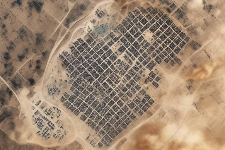
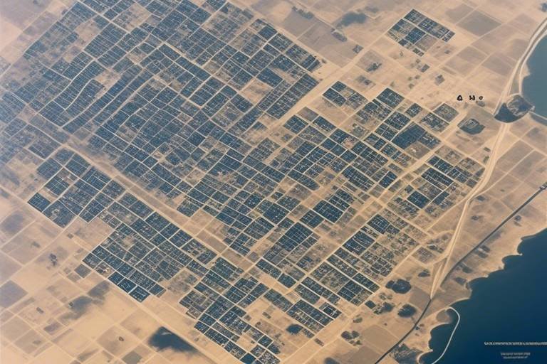
Military satellites significantly enhance surveillance and reconnaissance capabilities, providing real-time imagery and intelligence that are critical for situational awareness in urban environments. With the ability to capture high-resolution images and monitor troop movements, these satellites allow commanders to gain a comprehensive understanding of the battlefield. This is particularly important in urban settings where the risk of ambush and civilian casualties is high. By utilizing advanced imaging technology, military satellites can penetrate cloud cover and provide clear visuals even in adverse weather conditions.
Robust communication systems enabled by military satellites facilitate secure and reliable communication among ground forces, ensuring coordinated efforts during urban combat operations. In the heat of battle, every second counts, and the ability to communicate effectively can be the difference between life and death. Military satellites create a network that allows for seamless data exchange, even in the most challenging environments.
The ability to transmit large amounts of data quickly is vital for military operations, allowing for timely decision-making and tactical adjustments in urban warfare scenarios. For instance, real-time video feeds from drones can be sent directly to command centers, enabling leaders to make informed decisions based on the latest developments on the ground. This rapid data transmission capability ensures that military units can adapt to changing circumstances without delay.
Military satellites provide secure channels for communication, reducing the risk of interception by adversaries and ensuring that sensitive information remains confidential. In a world where cyber threats are prevalent, the security of military communications is paramount. Satellite technology offers encryption and other security measures that protect against eavesdropping, allowing military personnel to communicate without fear of compromise.
Satellite communication networks offer resilience against ground-based disruptions, maintaining connectivity even in the most challenging urban landscapes. Whether it’s due to damaged infrastructure or enemy interference, the reliability of satellite communications ensures that military operations can continue smoothly. This resilience is crucial for maintaining command and control in dynamic combat situations.
Real-time coordination between different military units is essential in urban warfare, and satellite systems play a pivotal role in enabling this level of operational synergy. By providing a common operational picture, satellites ensure that all units are on the same page, facilitating joint operations and minimizing the risk of friendly fire. This level of coordination is especially important in urban warfare, where the proximity of combatants can lead to catastrophic mistakes.
Military satellites enhance targeting accuracy for precision strikes, minimizing collateral damage and increasing the effectiveness of operations in urban settings. The stakes are incredibly high in urban warfare, where civilians often live in close proximity to combatants. Satellites enable military forces to identify and engage targets with pinpoint accuracy, significantly reducing the risk of unintended harm to non-combatants.
Geospatial intelligence gathered from satellites aids in identifying key targets and assessing the urban landscape, which is crucial for planning effective military strategies. By analyzing terrain, infrastructure, and enemy positions, military planners can devise strategies that leverage the strengths of their forces while mitigating vulnerabilities. This intelligence is invaluable for ensuring that operations are conducted efficiently and safely.
The use of military satellites for precision targeting also considers civilian safety, striving to mitigate risks to non-combatants during urban military engagements. The ethical implications of warfare are significant, and military planners are increasingly focused on minimizing civilian casualties. By employing satellite technology to enhance targeting precision, the military can conduct operations that are not only effective but also responsible.
Satellites assist in logistics and supply chain management by providing real-time tracking of resources, ensuring that military units are adequately supported during urban missions. In a fast-paced combat environment, the timely delivery of supplies can be a game-changer. Satellites enable commanders to monitor the location and status of supplies, allowing for quick adjustments to logistics plans as needed.
Effective resource allocation is critical in urban warfare, and satellite technology helps commanders make informed decisions about deploying supplies and reinforcements. By analyzing real-time data, military leaders can determine where resources are most needed and ensure that troops are well-equipped to face the challenges of urban combat.
Operational planning benefits from satellite data, allowing military leaders to anticipate challenges and optimize their strategies for urban combat scenarios. This foresight is essential for success in complex urban environments, where every decision can have far-reaching consequences. By leveraging satellite intelligence, military planners can craft detailed strategies that account for the unique dynamics of urban warfare.
- How do military satellites improve situational awareness? Military satellites provide real-time data and imagery, allowing commanders to understand the battlefield dynamically.
- What role do satellites play in communication during urban warfare? They facilitate secure and reliable communication, ensuring that military units can coordinate effectively.
- Can satellites help minimize civilian casualties? Yes, through precision targeting and enhanced intelligence, satellites help military forces engage targets more accurately.
Surveillance and Reconnaissance
In the realm of urban warfare, where every alleyway and building can be a potential battleground, play a crucial role in ensuring military success. Military satellites have revolutionized the way armed forces gather intelligence, providing an unparalleled view of densely populated areas. Imagine being able to see a city from above, where every movement can be tracked, and every strategic position can be analyzed. This capability is not just a technological marvel; it’s a game changer in modern combat.
One of the most significant advantages of using military satellites for surveillance is the ability to obtain real-time imagery. This means that commanders on the ground can access up-to-the-minute data about enemy movements, potential threats, and even civilian activity. Such information is vital for making informed decisions that could mean the difference between success and failure in urban environments. For instance, if a commander learns of a buildup of enemy forces in a specific area, they can adjust their tactics accordingly, deploying forces to counteract that threat or avoid unnecessary conflict.
Moreover, the advanced sensors equipped on these satellites allow for a variety of reconnaissance tasks, including:
- Thermal imaging to detect hidden enemy positions.
- Infrared capabilities for night-time operations.
- High-resolution cameras that capture detailed images of targets.
These technologies not only enhance situational awareness but also contribute to the safety of both military personnel and civilians. By accurately identifying threats and assessing the urban landscape, military planners can develop strategies that minimize collateral damage. This is particularly crucial in urban settings, where the presence of non-combatants complicates military operations.
Furthermore, the integration of satellite data with other intelligence sources creates a comprehensive picture of the battlefield. This synergy is essential for effective planning and execution of military operations. For example, when combined with data from drones or ground-based sensors, satellite imagery can provide a multi-dimensional view of the operational environment, allowing for more precise targeting and resource allocation.
In conclusion, the role of military satellites in surveillance and reconnaissance cannot be overstated. Their ability to provide real-time, detailed information significantly enhances the operational capabilities of armed forces in urban warfare. As technology continues to evolve, the reliance on these systems will only grow, shaping the future of military engagements in complex urban landscapes.
Communication Systems
The role of in modern urban warfare cannot be overstated. As military operations increasingly take place in densely populated areas, the need for robust and reliable communication channels becomes paramount. Military satellites serve as the backbone of these communication systems, enabling ground forces to maintain contact with each other and command centers even in the most chaotic environments. Imagine trying to coordinate a complex dance in a crowded room; every misstep can lead to disaster. This is akin to urban warfare, where clear communication can mean the difference between success and failure.
One of the key advantages of satellite communication is its ability to provide secure and encrypted channels. This means that sensitive information can be transmitted without the fear of interception by adversaries. In urban warfare, where the stakes are high and the consequences of compromised information can be dire, this security feature is invaluable. Military personnel can relay tactical updates, request air support, or call for reinforcements with confidence, knowing that their communications are protected.
Moreover, satellite communication systems are designed to be resilient. Urban environments can disrupt traditional communication methods, such as radio signals, due to buildings and other obstacles. However, satellites operate above these challenges, ensuring that military units remain connected even when ground-based systems fail. This resilience is crucial, as it allows for uninterrupted coordination among units, which is essential for effective combat operations.
Another critical aspect of communication systems is their capacity for data transmission. In the fast-paced world of urban warfare, commanders need to make quick decisions based on real-time information. Military satellites enable the rapid transfer of large volumes of data, including surveillance images, reconnaissance reports, and troop movements. This capability allows military leaders to adjust their strategies on the fly, responding to evolving situations and ensuring that operations remain fluid and adaptive.
As previously mentioned, the security of communication channels is a significant advantage provided by military satellites. By utilizing advanced encryption methods, these systems ensure that even if data is intercepted, it remains unreadable to unauthorized parties. This layer of security is particularly important in urban settings, where the presence of civilians complicates military operations. By safeguarding their communications, military forces can maintain operational integrity and protect both their personnel and innocent bystanders.
In addition to security, the resilience of satellite communication networks is a game-changer for urban warfare. Ground-based communication systems are often vulnerable to disruption from enemy actions or environmental factors. However, satellites, stationed high above the battlefield, can maintain connectivity regardless of the chaos below. This uninterrupted communication stream allows for seamless coordination among units, ensuring that every soldier knows their role and can respond to commands without delay.
Real-time coordination is essential for success in urban combat scenarios. Military satellites facilitate this by providing a platform for instant communication among various units. For example, if a squad encounters unexpected resistance, they can quickly relay their situation to command, who can then dispatch additional support or adjust the overall strategy. This level of responsiveness is crucial in urban warfare, where the dynamic nature of the environment can change in an instant.
In summary, military satellites play a vital role in enhancing communication systems during urban warfare. By providing secure, resilient, and efficient communication channels, they empower military forces to operate effectively in complex and challenging environments. As technology continues to evolve, the integration of satellite systems into military operations will only become more pronounced, further shaping the future of urban combat.
- How do military satellites improve communication during urban warfare?
Military satellites provide secure, resilient communication channels that enable real-time coordination among ground forces, ensuring effective operations in complex urban environments.
- What are the advantages of satellite communication over traditional methods?
Satellite communication offers enhanced security, resilience against disruptions, and the ability to transmit large amounts of data quickly, which is essential for timely decision-making in urban warfare.
- Can satellite communication be intercepted?
While satellite communications can be intercepted, they utilize advanced encryption methods to protect sensitive information, making it difficult for adversaries to decipher the data.
Data Transmission
In the fast-paced world of urban warfare, the ability to transmit data swiftly and efficiently is not just an advantage; it's a necessity. Military satellites play a pivotal role in this aspect, allowing for the rapid transfer of vital information across vast distances. Imagine a bustling cityscape where every second counts—military units need to react to threats, coordinate movements, and share intelligence in real-time. This is where satellite technology shines, acting as the backbone of communication in complex urban environments.
One of the standout features of military satellites is their capability to handle vast amounts of data simultaneously. This includes everything from high-resolution imagery to live video feeds, which are crucial for making informed decisions on the battlefield. For instance, when a reconnaissance team spots an enemy position, the information can be transmitted back to command centers almost instantaneously, allowing for quick tactical adjustments. In urban settings, where the landscape can change rapidly, this speed can mean the difference between success and failure.
Moreover, the efficiency of data transmission is enhanced by advanced compression algorithms and sophisticated encoding techniques. These technologies ensure that even in bandwidth-constrained environments, critical information is relayed without significant delays. The result? A seamless flow of data that keeps military operations synchronized and responsive. To illustrate this, consider the following table showcasing the types of data transmitted via military satellites:
| Type of Data | Description |
|---|---|
| Imagery | High-resolution images for surveillance and reconnaissance. |
| Video Feeds | Live video streams from drones or ground units. |
| Communications | Secure voice and text communications between units. |
| Geospatial Data | Maps and terrain information for strategic planning. |
Additionally, the reliability of data transmission is critical in urban warfare. Military satellites are designed to function in various conditions, ensuring that communication lines remain open even amidst electronic warfare or physical obstructions. This resilience is paramount when ground forces are navigating through densely populated areas where traditional communication methods may falter due to interference or damage.
Ultimately, effective data transmission through military satellites not only enhances operational efficiency but also significantly contributes to the safety of personnel involved. By ensuring that units are well-informed and coordinated, the risk of miscommunication and the potential for collateral damage are greatly reduced. In the chaotic theater of urban combat, where every moment is fraught with danger, having a reliable means of data transmission is akin to having a lifeline that connects all elements of the operation.
- How do military satellites improve communication in urban warfare?
Military satellites provide secure, reliable channels for communication, allowing ground forces to coordinate effectively even in challenging environments. - What types of data can military satellites transmit?
They can transmit high-resolution imagery, live video feeds, secure communications, and geospatial data, all of which are essential for informed decision-making. - Why is data transmission speed critical in urban warfare?
In urban combat, the landscape can change rapidly. Quick data transmission allows military units to react promptly to threats and make tactical adjustments. - How do military satellites ensure data security?
Military satellites use advanced encryption and secure communication protocols to protect sensitive information from interception by adversaries.
Secure Channels
In the chaotic realm of urban warfare, the **need for secure communication channels** cannot be overstated. Military satellites play a pivotal role in establishing these channels, ensuring that sensitive information is transmitted without the risk of interception. Imagine being in the middle of a high-stakes operation, where every second counts, and the last thing you want is for your plans to be compromised by enemy forces. This is where the advanced encryption technologies utilized by military satellites come into play, creating a **digital fortress** around communications.
These secure channels are not merely a luxury; they are a necessity. In urban environments, where the **density of civilian populations** complicates military operations, the ability to communicate securely can mean the difference between success and failure. With the threat of electronic warfare and eavesdropping ever-present, military satellites employ sophisticated measures to safeguard communications. This includes:
- Advanced Encryption: Military satellites utilize cutting-edge encryption algorithms to protect data in transit, ensuring that even if intercepted, the information remains unintelligible to adversaries.
- Frequency Hopping: This technique involves rapidly changing the transmission frequency, making it difficult for enemies to lock onto the communication signal.
- Secure Protocols: The implementation of secure communication protocols ensures that only authorized personnel can access sensitive information.
Moreover, the **redundant nature of satellite communication networks** adds an extra layer of security. If one channel is compromised or disrupted, alternative pathways can be utilized, ensuring that the flow of information remains uninterrupted. This resilience is crucial in urban warfare, where the environment can be unpredictable and hostile. The ability to maintain secure communication channels not only protects military assets but also enhances operational effectiveness, allowing for swift adjustments in tactics and strategies based on real-time intelligence.
In conclusion, secure channels established by military satellites are the backbone of modern urban warfare operations. They provide the necessary **confidence and clarity** that military leaders need to make informed decisions, coordinate efforts, and ultimately achieve their objectives while minimizing risks to both military personnel and civilians alike.
- How do military satellites ensure secure communication? Military satellites employ advanced encryption, frequency hopping, and secure protocols to protect data and ensure that only authorized users can access sensitive information.
- What happens if a secure channel is compromised? Satellite communication networks are designed with redundancy, allowing for alternative pathways to be utilized if one channel is disrupted, ensuring uninterrupted communication.
- Why is secure communication important in urban warfare? In urban warfare, the risk of interception is high due to the proximity of civilian populations and enemy forces. Secure communication helps protect military strategies and personnel.
Network Resilience
In the chaotic environment of urban warfare, where the landscape is often riddled with obstacles and potential threats, becomes a cornerstone of military operations. Imagine a spider weaving its web; each strand must remain intact to ensure the whole structure holds firm. Similarly, military satellite communication networks are designed to maintain connectivity even when ground-based systems are compromised. This resilience is crucial, as urban areas can present numerous challenges including damaged infrastructure, electronic warfare, and the presence of hostile forces.
One of the key advantages of utilizing military satellites is their ability to provide uninterrupted communication channels. These satellites operate above the fray, unaffected by the physical destruction that may occur below. For instance, if a city block is bombed and local communication lines are severed, military units can still rely on satellite communications to coordinate their efforts. This capability is akin to having a lifeline that remains intact while everything else crumbles around it.
Moreover, the deployment of multiple satellites in various orbits ensures that even if one satellite is taken out of commission, others can take over its responsibilities. This redundancy is vital for maintaining operational continuity. The military can achieve this through a combination of geostationary satellites, which provide constant coverage over a specific area, and low Earth orbit satellites, which offer quicker data transmission and can easily be repositioned as needed.
Additionally, secure communication channels established by military satellites help mitigate risks associated with enemy interception. In urban warfare, where the lines between combatants and non-combatants can blur, the need for secure communication is paramount. Imagine sending a text message in a crowded café; if someone is eavesdropping, your private conversation is at risk. Similarly, military operations require encrypted communications to ensure that sensitive information remains confidential and out of enemy hands.
In conclusion, the resilience of satellite networks is not merely a technical feature; it is a lifeline that enables military forces to operate effectively in the complex and unpredictable environments of urban warfare. With the ability to withstand disruptions and provide secure communication, military satellites empower ground forces to execute their missions with greater confidence and coordination.
- What is network resilience in military operations?
Network resilience refers to the ability of military communication systems, particularly those using satellites, to maintain operability despite challenges such as destruction of infrastructure or enemy interference. - How do satellites ensure secure communication?
Military satellites utilize encryption and secure channels to protect sensitive information from being intercepted by adversaries. - Why is redundancy important in satellite communications?
Redundancy ensures that if one satellite fails, others can take over its tasks, maintaining continuous communication and operational effectiveness.
Real-Time Coordination
In the chaotic realm of urban warfare, where every second counts and the stakes are extraordinarily high, among military units becomes not just beneficial, but essential. Imagine a bustling cityscape filled with narrow alleys, towering buildings, and civilians going about their daily lives. In such a complex environment, the ability to communicate and coordinate actions swiftly can mean the difference between mission success and catastrophic failure. Military satellites serve as the backbone of this coordination, providing a seamless flow of information that keeps ground forces connected, informed, and ready to act.
With satellite systems in place, commanders can relay orders and updates instantly, ensuring that every unit is on the same page. This is particularly vital when dealing with the unpredictable nature of urban combat, where threats can emerge from any direction, and the landscape can change dramatically in a matter of moments. The integration of satellite technology allows for a comprehensive view of the battlefield, enabling forces to adapt their strategies in real-time. For instance, if one unit encounters unexpected resistance, they can quickly communicate their situation to nearby units, allowing for immediate support or a strategic retreat.
Moreover, the precision of satellite data enhances situational awareness. Ground forces can receive live feeds of aerial imagery, showing troop movements, potential ambush points, and civilian locations. This information is not just crucial for military strategy; it also plays a significant role in protecting non-combatants. By having access to real-time data, commanders can make informed decisions that minimize the risk to civilians while achieving their operational goals.
To illustrate the importance of real-time coordination, consider the following table that outlines the key benefits of satellite-enabled communication in urban warfare:
| Benefit | Description |
|---|---|
| Instant Communication | Allows for immediate updates and orders between units, enhancing responsiveness. |
| Enhanced Situational Awareness | Provides live data on troop movements and environmental changes, aiding strategic planning. |
| Minimized Civilian Risk | Facilitates informed decision-making to protect non-combatants during operations. |
| Operational Flexibility | Enables quick adjustments to plans based on real-time intelligence and battlefield dynamics. |
In summary, the role of military satellites in enabling real-time coordination cannot be overstated. They transform the way military operations are conducted in urban environments, turning chaos into a manageable and strategic endeavor. As technology continues to evolve, we can expect these systems to become even more sophisticated, further enhancing the capabilities of our armed forces in the ever-complex landscape of urban warfare.
- How do military satellites improve communication in urban warfare?
Military satellites provide secure, real-time communication channels that allow ground forces to coordinate effectively, share intelligence, and respond quickly to changing situations. - What role does geospatial intelligence play in urban combat?
Geospatial intelligence from satellites helps identify key targets and assess the urban landscape, which is critical for planning effective military strategies. - How does satellite technology ensure civilian safety during military operations?
By providing real-time data and situational awareness, satellite technology enables commanders to make informed decisions that minimize risks to civilians while conducting military operations.
Targeting and Precision Strikes
The role of military satellites in enhancing targeting accuracy for precision strikes cannot be overstated. In the chaotic environment of urban warfare, where buildings and civilians are often intermingled, the ability to pinpoint targets with laser-like focus is crucial. Imagine trying to hit a bullseye at a carnival game while standing on a moving platform—this is akin to the challenges faced without satellite support. Military satellites provide the necessary data and intelligence, allowing forces to make informed decisions that minimize collateral damage and increase operational effectiveness.
One of the key components of this capability is geospatial intelligence. Satellites equipped with high-resolution imaging technology can capture detailed images of urban landscapes, revealing not only the locations of enemy forces but also the surrounding infrastructure. This information is invaluable for military strategists who must navigate the complexities of urban environments. For instance, understanding the layout of a city can help in planning routes for troop movements or identifying potential ambush points. The integration of this data into operational planning ensures that strikes are not only effective but also strategically sound.
Furthermore, the impact on civilian safety is a critical consideration in modern military operations. With the increasing awareness of the humanitarian implications of warfare, military forces are now more than ever focused on minimizing risks to non-combatants. Precision targeting facilitated by satellite technology allows for strikes that are both accurate and controlled. This is particularly important in urban settings, where the presence of civilians is unavoidable. By employing advanced algorithms and real-time data, military planners can assess the potential impact of their actions and adjust their strategies accordingly.
To illustrate the importance of precision targeting, consider the following table that outlines the advantages of satellite-assisted strikes compared to traditional methods:
| Aspect | Traditional Methods | Satellite-Assisted Methods |
|---|---|---|
| Target Accuracy | Low | High |
| Collateral Damage | High | Minimal |
| Operational Efficiency | Moderate | Enhanced |
| Real-Time Data | Limited | Abundant |
This table clearly demonstrates the transformative effect that satellite technology has on military operations. The shift from traditional methods to satellite-assisted approaches not only improves the effectiveness of military strikes but also aligns with the ethical considerations that modern warfare demands.
In conclusion, the integration of military satellites into targeting and precision strikes represents a significant advancement in urban warfare tactics. By leveraging advanced technologies, military forces can achieve their objectives with greater accuracy while safeguarding civilian lives. As conflicts increasingly take place in populated areas, the importance of these satellite systems will only continue to grow, shaping the future of military engagements.
- How do military satellites improve targeting accuracy?
Military satellites provide high-resolution imagery and geospatial intelligence that help identify and assess targets in urban environments. - What are the ethical considerations of using satellites in warfare?
Using satellites for precision targeting aims to minimize collateral damage and protect civilian lives during military operations. - Can satellite technology be disrupted?
While satellite systems are robust, they can be vulnerable to electronic warfare tactics; however, many military satellites are designed to withstand such threats.
Geospatial Intelligence
Geospatial intelligence (GEOINT) is a game-changer in the realm of urban warfare, providing military forces with a visual and analytical edge that is indispensable for modern combat operations. Imagine standing on the battlefield, equipped with a detailed map that not only shows you the terrain but also highlights potential threats and opportunities. That's the power of GEOINT. It combines satellite imagery, mapping data, and various other forms of intelligence to create a comprehensive picture of the operational environment.
In urban settings, where every building and alley can become a tactical advantage or a deadly trap, the ability to analyze and interpret geospatial data is crucial. Military satellites orbiting above gather vast amounts of information, capturing high-resolution images of cities and their infrastructures. This data is then transformed into actionable intelligence that helps commanders make informed decisions. For instance, they can assess the layout of a city block, identify key infrastructure such as bridges and power plants, and even spot potential hiding places for enemy combatants.
Furthermore, the integration of geospatial intelligence into military strategy allows for:
- Enhanced Target Identification: By analyzing satellite images, military planners can pinpoint critical targets with high accuracy, ensuring that operations are both effective and precise.
- Urban Terrain Analysis: GEOINT provides insights into the urban landscape, helping troops understand the best routes for movement and the most strategic positions for engagement.
- Predictive Analytics: Advanced algorithms can forecast enemy movements and behaviors based on historical data, allowing for proactive measures rather than reactive responses.
Moreover, the role of geospatial intelligence extends beyond immediate tactical advantages. It also plays a significant part in long-term strategic planning. By understanding the geographical and cultural nuances of urban areas, military leaders can devise strategies that minimize civilian casualties and enhance the overall effectiveness of their operations. This is particularly important in today's world, where the lines between combatants and non-combatants are often blurred.
As technology advances, the capabilities of GEOINT will only expand. With the integration of artificial intelligence and machine learning, the analysis of geospatial data will become faster and more accurate. This transformation will enable military forces to respond to dynamic urban environments with unprecedented speed and precision. In essence, geospatial intelligence is not just about gathering data; it’s about transforming that data into a powerful tool for success in urban warfare.
- What is geospatial intelligence? Geospatial intelligence (GEOINT) is the collection and analysis of geographic information to support military operations and decision-making.
- How do military satellites contribute to GEOINT? Military satellites provide high-resolution imagery and data that help in analyzing urban landscapes, identifying targets, and planning operations.
- Why is geospatial intelligence important in urban warfare? In urban warfare, understanding the terrain, infrastructure, and potential threats is crucial for effective strategy and minimizing civilian casualties.
- What technologies enhance geospatial intelligence? Technologies such as artificial intelligence, machine learning, and advanced imaging techniques enhance the capabilities of geospatial intelligence.
Impact on Civilian Safety
In the realm of urban warfare, where the lines between combatants and civilians can blur, the importance of protecting non-combatants cannot be overstated. Military satellites play a pivotal role in enhancing civilian safety during conflicts. By providing precise geospatial intelligence, these satellites allow military forces to identify key targets with remarkable accuracy, thereby minimizing the risk of collateral damage. Imagine a surgeon meticulously navigating through a complex operation; that’s how military strategists use satellite data to ensure their strikes are as precise as possible.
Moreover, the integration of satellite technology into military operations means that commanders have access to real-time data. This capability allows them to adapt their strategies on the fly, responding to emerging threats while still considering the safety of civilians. For instance, if a civilian area is identified near a target, military forces can recalibrate their approach, opting for alternative methods that reduce the likelihood of civilian casualties. This is akin to a chess player who, upon seeing an unexpected move, adjusts their strategy to protect their king.
Another critical aspect is the ability of military satellites to monitor civilian movements in urban areas. This information can be used to avoid engaging in areas with high civilian presence, ensuring that operations do not inadvertently put innocent lives at risk. By analyzing patterns and gathering data on population density, military planners can make informed decisions about when and where to engage.
In addition, the use of advanced imaging technology from military satellites allows for the assessment of damage after strikes. This feedback loop is essential for understanding the impact of military actions on civilian infrastructure and populations. By evaluating the aftermath, military forces can adjust their tactics in future operations to further minimize harm. The goal is not just to win battles but to preserve the integrity of communities and protect the lives of those who are not part of the conflict.
Ultimately, the impact of military satellites on civilian safety is a double-edged sword. While they provide the tools needed for precision and informed decision-making, the ethical implications of their use in urban warfare must always be considered. The challenge lies in balancing military objectives with the moral obligation to protect civilians. As technology continues to evolve, so too must the strategies that govern its use, ensuring that the safety of non-combatants remains a top priority.
- How do military satellites improve targeting accuracy?
Military satellites provide high-resolution imagery and real-time data, allowing forces to identify and assess targets with precision, which reduces collateral damage. - What measures are taken to ensure civilian safety during military operations?
Commanders use satellite data to avoid civilian areas, reassess targets, and adapt strategies on the fly to minimize risks to non-combatants. - Can satellite technology prevent civilian casualties?
While it cannot completely eliminate the risk, enhanced surveillance and real-time intelligence significantly reduce the chances of civilian casualties during military engagements. - How does satellite imagery help in post-strike assessments?
After an operation, satellite imagery can be analyzed to evaluate damage and civilian impact, guiding future military strategies to be more cautious and ethical.
Logistics and Supply Chain Management
In the chaotic realm of urban warfare, where every second counts and every decision can lead to success or failure, emerge as unsung heroes. Imagine a well-oiled machine, where every cog and wheel works in perfect harmony; this is what military logistics strive to achieve. The integration of military satellites into this process has revolutionized how forces operate in densely populated areas. With the ability to monitor and manage resources in real-time, military leaders can ensure that their troops are not just equipped, but are also strategically supported at all times.
One of the standout features of satellite technology is its capacity for real-time tracking. This capability allows commanders to have an up-to-the-minute view of their supplies, whether it be ammunition, food, or medical resources. For instance, consider a scenario where ground troops are engaged in a fierce urban battle. With satellite support, commanders can pinpoint exactly where their supplies are located, assess how quickly they can be delivered, and make rapid decisions about resource allocation. This not only optimizes the efficiency of military operations but also enhances the morale of troops who know that support is just a call away.
Furthermore, the data gathered from military satellites is invaluable for operational planning. By analyzing satellite imagery and logistical data, military leaders can anticipate potential challenges in urban environments. For example, they can identify choke points in supply routes or assess the impact of urban infrastructure on logistics. This foresight allows for the development of comprehensive strategies that account for the unique challenges of urban warfare.
| Logistics Challenges | Satellite Solutions |
|---|---|
| Supply route disruptions | Real-time monitoring of routes and alternative paths |
| Resource shortages | Immediate assessment of stock levels and needs |
| Coordination between units | Instant communication and data sharing |
In addition to tracking and planning, military satellites also play a crucial role in resource allocation. Imagine trying to fill a glass with water while blindfolded; without proper guidance, you risk overfilling or missing the glass entirely. Similarly, effective resource allocation in urban warfare requires precise information about where and when to deploy supplies. With satellite technology, commanders can analyze data on troop movements and needs, ensuring that resources are deployed efficiently and effectively.
Moreover, the integration of satellite technology into logistics allows for a more agile response to unforeseen circumstances. Urban environments are notoriously unpredictable, and the ability to adapt quickly can mean the difference between victory and defeat. For instance, if a supply convoy encounters unexpected resistance, satellite data can help redirect resources to alternative routes or provide immediate air support as needed. This flexibility is crucial in maintaining operational momentum in urban combat scenarios.
As we delve deeper into the complexities of urban warfare, it becomes increasingly clear that the role of military satellites in logistics and supply chain management is not just beneficial, but essential. They serve as the backbone of modern military operations, ensuring that every soldier is equipped, informed, and ready to face the challenges of urban combat.
- How do military satellites improve logistics in urban warfare?
Military satellites provide real-time tracking and monitoring of supplies, allowing for efficient resource allocation and operational planning. - What are the main challenges in urban logistics?
Challenges include supply route disruptions, resource shortages, and coordination between units, all of which can be mitigated with satellite support. - Can satellite technology adapt to unexpected situations?
Yes, satellite technology allows for quick adjustments and alternative planning in response to unforeseen challenges during operations.
Resource Allocation
In the chaos of urban warfare, effective can make the difference between victory and defeat. With densely populated areas posing unique challenges, military commanders rely heavily on satellite technology to streamline their operations. Imagine a bustling city, where every street corner could hide a threat, and every building could serve as a vantage point for enemy forces. In such scenarios, having the right resources at the right time is not just advantageous; it’s essential.
Military satellites play a vital role in ensuring that resources, including personnel, ammunition, and medical supplies, are deployed efficiently. They provide real-time data that allows commanders to assess the situation on the ground, facilitating informed decisions about where to allocate resources. For instance, if a particular area is under heavy fire, satellite imagery can quickly reveal the intensity of the conflict, prompting immediate reinforcements or supply drops.
Moreover, the ability to track resources in real-time means that military units can avoid the pitfalls of over- or under-supply. This is especially important in urban environments where logistical routes can be unpredictable. By utilizing satellite data, commanders can establish a clear picture of their supply chain, ensuring that every unit receives what it needs without delay. This approach not only enhances operational efficiency but also boosts the morale of troops who know that support is just a call away.
To illustrate the impact of satellite-assisted resource allocation, consider the following table:
| Resource Type | Importance in Urban Warfare | Satellite Role |
|---|---|---|
| Personnel | Critical for ground operations | Tracking locations and movements |
| Ammunition | Essential for sustained combat | Real-time inventory management |
| Medical Supplies | Vital for casualty care | Ensuring timely delivery to units |
| Fuel | Necessary for vehicle mobility | Monitoring consumption rates |
This table highlights how different types of resources are interlinked with satellite capabilities, emphasizing the comprehensive support that satellite technology provides. As military operations evolve, the integration of satellite data into resource allocation strategies will continue to enhance the effectiveness of urban warfare tactics.
In conclusion, resource allocation in urban warfare is a complex yet crucial aspect of military strategy. The use of military satellites not only optimizes the distribution of supplies and personnel but also ensures that operations remain fluid and responsive to the ever-changing battlefield dynamics. With the stakes so high, leveraging satellite technology is no longer a luxury; it’s a necessity for modern military forces.
- How do military satellites improve resource allocation?
Military satellites provide real-time data and imagery, allowing commanders to make informed decisions about where to allocate resources effectively. - What types of resources are most critical in urban warfare?
Personnel, ammunition, medical supplies, and fuel are among the most critical resources needed for successful operations in urban environments. - Can satellite communication be disrupted in urban warfare?
While urban environments can pose challenges for satellite communication, these systems are designed to be resilient and maintain connectivity even in difficult conditions.
Operational Planning
In the realm of urban warfare, is not just a necessity; it’s an art form. Military leaders face a complex tapestry of challenges when navigating the crowded streets and towering structures of a city. Here, the role of military satellites becomes invaluable. By providing a wealth of real-time data, these satellites enable commanders to craft strategies that are both dynamic and responsive to the ever-changing battlefield conditions.
Imagine orchestrating a symphony where every note must harmonize perfectly, even as the tempo shifts unexpectedly. This is akin to how military planners must approach their operations in urban settings. With the aid of satellite imagery and geospatial intelligence, they can visualize the entire landscape, identifying key infrastructure, potential ambush points, and civilian areas that must be protected. Such detailed insights allow for the formulation of strategies that maximize effectiveness while minimizing risk.
Moreover, operational planning is not a one-time event; it is a continuous process. As situations evolve, so too must the strategies. Military satellites facilitate this by allowing for real-time updates. For instance, if a unit encounters unexpected resistance or if civilian movements change, commanders can quickly adjust their plans. This adaptability is crucial in urban warfare, where the stakes are high, and the margin for error is razor-thin.
One of the key advantages of using satellites in operational planning is their ability to integrate various data points. This includes not only surveillance data but also logistical information and troop movements. By synthesizing these elements, commanders can create a comprehensive operational picture. Here's a simple breakdown of how this integration works:
| Data Type | Purpose |
|---|---|
| Surveillance Data | Identifies enemy positions and civilian areas |
| Logistical Information | Tracks supply routes and resource availability |
| Troop Movements | Coordinates units to prevent friendly fire |
This table illustrates how diverse data types come together to enhance operational planning. Each piece of information contributes to a clearer understanding of the battlefield, allowing for informed decision-making that can potentially save lives and increase mission success rates.
In addition to real-time data integration, the predictive capabilities of satellite technology play a crucial role in operational planning. By analyzing historical data and current trends, military analysts can forecast potential scenarios, enabling them to prepare for various contingencies. This foresight is akin to having a weather forecast before a big event; it allows planners to anticipate challenges and devise solutions in advance.
Ultimately, the integration of military satellites into operational planning transforms the way urban warfare is conducted. It empowers commanders with the tools they need to navigate the complexities of city combat, ensuring that every operation is executed with precision and care. As urban environments continue to evolve, so too will the strategies that military leaders employ, with satellites remaining at the forefront of this critical evolution.
- How do military satellites improve communication during urban warfare?
Military satellites provide secure and reliable communication channels that allow ground forces to coordinate effectively, even in densely populated areas. - What role does geospatial intelligence play in targeting?
Geospatial intelligence helps identify key targets and assess urban landscapes, which is essential for planning precise military strikes. - Can military satellites help protect civilians during operations?
Yes, by enhancing targeting accuracy and providing real-time data, military satellites help minimize collateral damage and prioritize civilian safety.
Frequently Asked Questions
- What role do military satellites play in urban warfare?
Military satellites are crucial in urban warfare as they provide real-time surveillance, reconnaissance, and communication capabilities. They help military forces maintain situational awareness in densely populated areas, enabling more effective and strategic operations.
- How do military satellites enhance communication among ground forces?
Military satellites facilitate secure and reliable communication channels that allow ground forces to coordinate their efforts effectively during urban combat. This ensures that all units are synchronized, which is essential for successful operations in complex environments.
- What are the benefits of using satellites for data transmission in military operations?
The ability to transmit large amounts of data quickly is vital for military operations. Satellites enable timely decision-making and tactical adjustments, ensuring that commanders can respond rapidly to changing situations on the ground.
- How do military satellites ensure secure communication?
Military satellites provide secure communication channels that reduce the risk of interception by adversaries. This confidentiality is crucial for maintaining operational security and protecting sensitive information during missions.
- What impact do military satellites have on targeting and precision strikes?
Military satellites enhance targeting accuracy for precision strikes, which helps minimize collateral damage and increases the effectiveness of operations in urban settings. They provide vital geospatial intelligence that aids in identifying key targets.
- How do military satellites contribute to civilian safety during operations?
When conducting precision targeting, military satellites play a role in assessing the urban landscape, which helps to mitigate risks to non-combatants. This focus on civilian safety is a critical aspect of modern military engagements.
- In what ways do satellites assist with logistics and supply chain management?
Satellites provide real-time tracking of resources, which is essential for ensuring that military units are adequately supported during urban missions. This capability allows for effective resource allocation and operational planning.
- How does satellite technology aid in operational planning?
Satellite data allows military leaders to anticipate challenges and optimize their strategies for urban combat scenarios. This foresight is crucial for successful mission execution in the unpredictable urban landscape.